

Seeing the Forest and the Trees
One of the most significant applications of repeat satellite imagery is monitoring the health of our planet's ecosystems. A single image might show a lush forest, but a time-lapse series can reveal the subtle or sudden creep of deforestation. Analysts
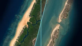
can track illegal logging operations by identifying the appearance of new roads in protected areas or quantify the rate of canopy loss over seasons and years. This frequent, wide-area coverage is far more effective than slow or expensive ground surveys. Beyond forests, this technology helps manage water resources by tracking shoreline changes, reservoir levels, and even early warnings for harmful algal blooms. Using spectral data invisible to the naked eye, scientists can assess vegetation health, soil moisture, and land surface temperature, providing a comprehensive check-up on the environment.
Charting the Growth of Our Cities
The world is becoming increasingly urban, and satellite time-lapses provide a dramatic visual record of this expansion. Researchers can watch as cities like Las Vegas or Dubai sprawl into surrounding deserts, or as agricultural land is converted into suburbs. This isn't just about making compelling videos; it's crucial data for urban planners. By monitoring the pace and pattern of urban growth, officials can better manage infrastructure demands, plan for public services, and understand the environmental impact of development. Time-series data helps track the effectiveness of transportation systems and ensures that urban expansion is sustainable. It provides a clear, objective measure of how human settlements are evolving on a global scale.
A Crucial Tool in Disaster Response
When a natural disaster strikes, getting a clear picture of the situation on the ground is paramount. Satellites provide a consistent eye in the sky, even when conditions like heavy rain or smoke make traditional monitoring impossible. For emergency managers, before-and-after images are invaluable. They can rapidly map the extent of flooding, assess building damage, identify which roads are blocked, and pinpoint communities at risk. This sharply reduces response times and allows for more effective allocation of resources, from guiding evacuations to planning helicopter supply drops. In the aftermath, repeated images help track recovery efforts, such as the restoration of power grids and other critical infrastructure.
Uncovering Secrets of the Past
It may seem counterintuitive, but looking down from space can help us see deep into the past. The field of 'satellite archaeology' uses high-resolution imagery to find clues to ancient, buried structures that are invisible from the ground. An archaeologist, Dr. Sarah Parcak, has used this method to identify thousands of potential sites in Egypt, including 17 possible pyramids and the full street plan of the ancient city of Tanis. By analyzing subtle variations in the soil and vegetation that can't be seen by the naked eye, researchers can detect the faint outlines of man-made structures hidden beneath the surface. This allows archaeologists to map vast areas and focus their ground expeditions on the most promising locations, revolutionizing the search for lost civilizations.