




A Landmark Partnership in Orbit
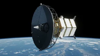
At the heart of this initiative is the NASA-ISRO Synthetic Aperture Radar, or NISAR, mission. This joint Earth-observing satellite represents a historic collaboration between the two space agencies, combining their expertise to create one of the most
advanced remote sensing platforms ever launched. ISRO provided the S-band radar system and the spacecraft itself, while NASA contributed the L-band radar and a massive 39-foot reflector antenna. Launched from Indian soil, NISAR orbits the Earth, systematically scanning nearly the entire globe every 12 days, providing a consistent and reliable stream of high-resolution data. Its primary objective is to study the planet's changing surfaces, from shifting ice sheets to the subtle movements of land, but one of its most critical applications for India is disaster management.
The All-Weather Advantage of SAR
What makes NISAR so special for flood monitoring? The answer lies in its Synthetic Aperture Radar (SAR) technology. Unlike traditional optical satellites that function like a camera and are blinded by clouds, rain, and darkness, SAR is an active system. It sends out its own microwave pulses and reads the signals that bounce back, creating detailed images of the Earth's surface regardless of weather conditions or time of day. This is a game-changer for monitoring monsoon-related floods, which are inherently accompanied by heavy cloud cover. When calm floodwater covers the ground, it acts like a mirror, bouncing the radar signal away from the satellite; this makes flooded areas appear dark in SAR images, creating a stark contrast with the brighter-looking dry land. This allows scientists to map the extent of an inundation with remarkable accuracy, even through a storm.
From Raw Data to Actionable Maps
The raw data beamed down from NISAR is a complex stream of information that requires processing to become useful. At ISRO's National Remote Sensing Centre (NRSC), sophisticated algorithms turn this data into actionable intelligence. By comparing images taken before and during a flood, analysts can generate near-real-time maps highlighting the affected areas. These maps detail the extent of the flooding, showing which villages, roads, and farmlands are underwater. This information is then disseminated through ISRO's Disaster Management Support Programme to various central and state government agencies, including the National Disaster Management Authority (NDMA). In July 2026, ISRO made the S-band data from NISAR publicly available through its Bhoonidhi portal, allowing a wider community of researchers and disaster management officials to access these crucial datasets.
Saving Lives and Limiting Damage
The practical impact of this technology is immense. For disaster response teams on the ground, having accurate, up-to-date flood maps is critical. These maps help authorities plan evacuation routes, identify communities that are cut off and in need of immediate assistance, and strategically position relief supplies. Before, they were often working with incomplete information, especially in remote or cloud-covered areas. NISAR functions as a 'virtual stream gauge,' able to detect changes in water level even in areas with standing vegetation, providing data where no ground sensors exist. Post-disaster, the same data is invaluable for assessing the full extent of the damage to infrastructure and agriculture, enabling governments to allocate resources for recovery and reconstruction more efficiently. This rapid and precise assessment helps speed up the process of rebuilding and getting communities back on their feet.
More Than Just Floods
While flood monitoring is a key application for India, NISAR's capabilities extend much further. The dual-frequency radar system can penetrate vegetation canopies to monitor agricultural health and biomass, helping with crop yield forecasts. It tracks the slow movement of glaciers in the Himalayas, providing vital information on water resources and the impacts of climate change. The satellite also monitors land subsidence, seismic activity, and the risk of landslides, contributing to a comprehensive understanding of various geological hazards. By providing this wealth of information, the NISAR mission serves as a multi-purpose tool for scientific research and resource management across the country.