


The Annual Spectacle of Chaos
Every year, it’s the same story across Mumbai, Bengaluru, Delhi, and Chennai. Social media fills with images of submerged cars, commuters wading through knee-deep water, and navigation apps glowing a furious, static red. We call it 'unprecedented' rain,
but the 'unprecedented' has become an annual, predictable event. The spectacle of our cities grinding to a halt is not just an inconvenience; it is a massive economic and social drain. It exposes a fundamental flaw in how we manage our urban spaces. We are treating a chronic, recurring illness with temporary bandages, reacting to the flood instead of proactively planning for the water.
Why Our Routes Fail Us
The problem isn't just the rain; it's the routes. Our urban infrastructure was not designed for the current population density or the increasingly intense weather patterns. Drains are choked with plastic and silt, natural floodplains have been concreted over for real estate, and road networks lack the flexibility to handle sudden disruptions. When a key arterial road floods, the entire city's circulatory system seizes up. Current 'solutions' are painfully reactive: police manually diverting traffic, municipalities deploying pumps after the fact, and citizens relying on crowdsourced warnings on Twitter that are often outdated by the minute. This is not a strategy; it is a city-wide scramble for survival.
Embracing Dynamic Route Planning
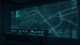
The solution lies in shifting from a static to a dynamic mindset. We need 'better route planning' that is intelligent, predictive, and integrated. Imagine a centralised city-wide system that doesn't just show you where the traffic jam *is*, but where it *will be* in the next 30 minutes. This isn't science fiction. It involves integrating real-time data from multiple sources: weather forecasts from the IMD, water-level sensors in underpasses and low-lying areas, traffic camera feeds, and real-time GPS data from public transport and ride-sharing services. By feeding this data into an AI-powered model, municipal authorities could predict which areas will flood and proactively reroute traffic *before* a gridlock occurs.
A Blueprint for a Smarter Monsoon
What would this system look like in practice? First, dynamic signage on major roads would automatically update to close off flood-prone routes and suggest alternatives. Second, public transport apps would reroute buses in real-time, sending alerts to commuters' phones. Third, emergency services like ambulances and fire brigades would be given pre-cleared, safe corridors to navigate the city. This level of coordination requires breaking down the silos that exist between the traffic police, the municipal corporation, the disaster management authority, and technology providers. It requires investment in a robust sensor network and a central command centre to analyse the data and make decisions. The cost of this investment pales in comparison to the billions lost in economic productivity, vehicle damage, and human suffering each year.
From Citizen Grievance to Civic Demand
For too long, we have accepted monsoon chaos as an unavoidable part of life. We complain on social media, share videos of our waterlogged streets, and then forget about it until the next downpour. This cycle of grievance must evolve into a sustained civic demand for better governance and smarter infrastructure. As citizens, we must push our elected officials and municipal bodies to prioritise long-term resilience over short-term fixes. We need to ask not just for our potholes to be filled, but for a comprehensive, technology-enabled plan for monsoon management. Our frustration needs a direction, and that direction is demanding a city that works for its people, even when it rains.