


Your Phone is Your First Line of Defence
Before you even start your engine, your smartphone is your most powerful tool. Modern navigation apps like Google Maps and Waze are no longer just for finding the quickest route; they are dynamic, real-time monitors of road conditions. These apps use
anonymised data from other travellers on the road to detect traffic jams. When a landslide occurs, the resulting standstill is quickly identified as a major blockage, often appearing as a dark red line on the map. Furthermore, users who are stuck can actively report the road closure. Look for icons indicating a closed road or hazard alerts. When planning your journey, always check the entire route on the app just before you leave. If you see a major, unexplained delay on a mountain road, it’s a significant red flag. Treat these digital warnings as your first, essential piece of intelligence.
Go Hyperlocal with Indian Mapping Tech
While global apps are excellent, it pays to have a local specialist in your toolkit. Consider downloading MapmyIndia’s Mappls app. As an Indian company, they have spent decades building detailed maps of the country, often with a level of granularity in tier-2 and tier-3 towns and rural areas that global competitors may lack. Mappls includes its own real-time traffic and safety features, which can be particularly useful in identifying local choke points or alternative routes that might not be as well-documented on other platforms. In regions prone to frequent disruptions, having a second, locally-focused mapping app can provide a crucial cross-reference, helping you make a more informed decision about whether a route is truly clear.
Trust Official Alerts Over App Algorithms
Navigation apps are reactive; they report a problem after it has happened. Official government alerts, on the other hand, are proactive. The Indian Meteorological Department (IMD) issues colour-coded weather warnings (yellow, orange, red) for heavy rainfall, which is the primary trigger for landslides. A red alert for a district you plan to travel through should be a non-negotiable reason to postpone your trip. Furthermore, the National Disaster Management Authority (NDMA) and its state-level counterparts (SDMAs) in places like Uttarakhand, Himachal Pradesh, and Sikkim provide specific advisories and updates. Before and during your trip, check the official websites and social media handles of the local traffic police and district administration. Their on-ground information is the most authoritative you can get.
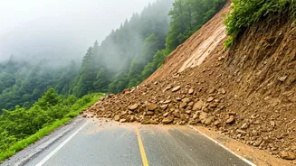
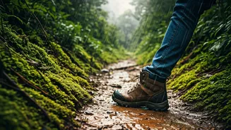
Look Up From the Screen: Reading the Road
Technology is a powerful aid, but it is not a substitute for your own senses. When driving in the hills during monsoon, you must be an active observer. Be vigilant for the tell-tale signs of an unstable hillside. These include small stones, pebbles, or soil trickling down a slope; cracks appearing on the road surface or hillside; trees, poles or fences leaning at odd angles; and sudden changes in streams, where clear water turns muddy. If you notice any of these signs, especially after heavy rain, the safest course of action is to not proceed. Find a safe, open area to pull over and assess the situation, or if possible, turn back. Your eyes are the most 'instant' tool you have.
The Human Network: Tap into Local Knowledge
Long before GPS, there was the local dhaba owner and the village taxi driver. This 'human network' remains one of the most reliable sources of information. When you stop for tea or a meal, ask about the road ahead. Local residents and commercial drivers have an intimate knowledge of the terrain. They know which areas are prone to slipping, which 'kaccha' roads are viable detours, and they often receive news of a road blockage via word-of-mouth or local WhatsApp groups long before it registers on any app. Placing trust in this local intelligence can save you from driving into a dangerous situation. A simple question—"Is the road to Shimla clear?"—can yield more valuable, up-to-the-minute information than hours of online searching.