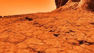

An Audacious Plunge into the Inferno
Sometime in the early 2030s, a spacecraft will arrive at Venus with a precious cargo: a one-meter-wide probe built to do the unthinkable. The DAVINCI mission, short for Deep Atmosphere Venus Investigation of Noble gases, Chemistry, and Imaging, will drop
this sphere into the planet's thick, toxic atmosphere. For about 63 minutes, it will descend through the clouds, sampling gases and snapping pictures, on a one-way trip to the surface. This will be the first U.S. probe to enter Venus's atmosphere in over 40 years, aiming to answer fundamental questions about our neighboring world. Unlike an orbiter that studies from afar, DAVINCI is designed for a daring, immersive plunge to investigate why a planet so similar in size to Earth became a scorching wasteland.
The Ultimate Photographic Challenge
Photographing Venus from below its cloud tops is no simple task. The planet is permanently shrouded in thick clouds of sulfuric acid, and its atmosphere is 90 times denser than Earth's, creating surface pressure that can crush a submarine. Temperatures hover around 475 degrees Celsius, hot enough to melt lead. These conditions have destroyed nearly every craft that has attempted a landing, with most surviving only minutes. The DAVINCI probe is designed to endure this punishment long enough to fulfill its mission. A key part of that mission is visual. The Venus Descent Imager (VenDI) will take hundreds of pictures as the probe falls, providing the first high-resolution look at a mountainous region called Alpha Regio. These won't just be pictures; they will be critical data for understanding the geology and history of this ancient, rugged terrain.
A Dress Rehearsal in the Desert
How do you prepare a camera for a world you can't see? You find a stand-in on Earth. In late June 2026, the DAVINCI team traveled to Crater Island, a mountainous complex in Utah's West Desert, to simulate the probe's photographic descent. The area's rugged geology serves as a good proxy for the Alpha Regio highlands on Venus. In a series of 10 flights, a helicopter carried a basket of instruments—including a prototype of the VenDI camera system—to an altitude of 18,000 feet before beginning a slow, 40-minute descent. As the helicopter descended, the cameras captured hundreds of images in near-infrared wavelengths, the same type of light DAVINCI will use to peer through Venus's thick haze.
Stitching Together a Hostile World
The goal of the Utah tests was to prove that the imaging system could successfully create detailed 3D maps of the terrain using only the pictures taken during descent. By stitching together the images, scientists were able to reconstruct the landscape with remarkable detail. They then compared their new maps to existing high-quality geological surveys of the area. The successful match gave the team confidence that their techniques will work on Venus, allowing them to map both the topography and chemical composition of the rocks below. These tests are not just about ensuring the hardware works; they are about perfecting the science of seeing a new world for the first time, transforming a sequence of images into a rich geological story.
Rewriting the Story of Earth's Twin
The data from DAVINCI promises to revolutionize our understanding of Venus. The mission's instruments will measure noble gases and chemical compounds to figure out how the atmosphere formed and evolved. A key goal is to determine if Venus ever had an ocean and a more temperate past, offering clues as to why it diverged so drastically from Earth's evolutionary path. The images of Alpha Regio could reveal whether Venus once had plate tectonics, similar to Earth. By combining atmospheric data with the first-ever high-resolution descent images of its surface, DAVINCI will provide a complete picture of a complex and mysterious world, from its upper atmosphere down to its ancient rocks.