



A New Sentinel in the Sky
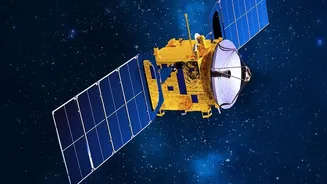
The game-changer is the NASA-ISRO Synthetic Aperture Radar, or NISAR, satellite. Launched in July 2025, this ambitious joint mission is the first to use two different radar frequencies (L-band and S-band) to monitor our planet's surface in unprecedented
detail. Orbiting the Earth at an altitude of 747 kilometres, NISAR revisits the same spot every 12 days, building a near-constant stream of data that tracks changes on the ground. While its mission is broad—covering everything from volcanic activity to melting glaciers—its impact on disaster management, particularly flood forecasting in India, is already proving to be revolutionary. Recent images of the Brahmaputra river during Assam's flood season demonstrate its power to help scientists and disaster managers track flooding and erosion with stunning clarity.
Seeing Through the Storm
So, what makes NISAR’s imagery so special? Unlike traditional optical satellites that need clear skies and daylight to take pictures, NISAR uses Synthetic Aperture Radar (SAR). Think of it like a camera with its own powerful flash that can penetrate clouds, smoke, and darkness. This is a critical advantage during India's monsoon season, when relentless cloud cover often blinds other satellites at the very moment they are needed most. The radar waves beam down to the surface and bounce back to the satellite, creating a detailed picture of the ground below regardless of the weather or time of day. This all-weather, day-night capability means that for the first time, authorities can get a clear, uninterrupted view of how a flood is developing.
From Pixels to Predictions
The true power of NISAR lies in how its data transforms forecasting. The satellite’s advanced radar can precisely map the extent of waterlogging, even detecting water under forest canopies or submerged vegetation—something that was incredibly difficult with previous technologies. Open water appears dark in its images, while flooded forests appear bright, allowing for a clear distinction. This high-resolution data is fed into hydrological models, dramatically improving their accuracy. By comparing images taken just days apart, scientists can measure changes in water levels down to the centimetre. This allows them to function as 'virtual stream gauges', providing crucial information for remote areas without ground sensors. This leads to more reliable and timely warnings, giving communities more lead time to evacuate and disaster response teams more accurate information to deploy resources effectively.
The Power of Partnership
The NISAR mission is a testament to the powerful collaboration between the Indian Space Research Organisation (ISRO) and the National Aeronautics and Space Administration (NASA). ISRO provided the S-band radar, the launch vehicle (GSLV), and is responsible for data processing and dissemination for the Indian region. NASA provided the L-band radar and other key components. This dual-frequency approach is a world-first, combining the strengths of both bands: the L-band is excellent for penetrating dense vegetation, while the S-band is sensitive to soil moisture and agricultural monitoring. ISRO began releasing the first batches of S-band data to the public in July 2026 through its Bhoonidhi data portal, making this invaluable information accessible for research and application.
The Real-World Impact on India
For a country as vast and geographically diverse as India, where floods are a recurrent and deadly threat, this technology is more than just a scientific achievement. More accurate forecasts directly translate into saved lives and protected livelihoods. For example, recent NISAR observations of the Brahmaputra river have provided an unprecedented view of its braided channels and floodplains, helping to understand its dynamic and destructive nature. With better foresight, agencies like the National Disaster Management Authority (NDMA) can move from a reactive stance to a proactive one. They can pre-position relief supplies, plan evacuation routes with greater confidence, and issue warnings that people are more likely to trust. From the Himalayan foothills to the coastal plains, NISAR is empowering India to build greater resilience against one of its most persistent natural challenges.