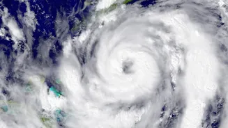









Arnab's Path After Landfall
Very Severe Cyclonic Storm Arnab crossed the Andhra Pradesh and Yanam coasts on Wednesday morning before weakening. The landfall process was completed by 8 a.m. on October 28, with the storm's center moving completely over land. At its peak during landfall,
the system brought maximum sustained wind speeds of 125-135 kmph, with gusts reaching up to 150 kmph. After crossing the coast, the system weakened into a Severe Cyclonic Storm and is now tracking north-northwest, carrying significant moisture and rainfall potential deep into the country's interior.
Which Inland States Are on Alert?
The IMD has issued alerts for several states as the cyclone's remnants move inland. Extremely heavy rainfall is forecast for isolated places in Chhattisgarh and Odisha. A red alert was issued for several southern Odisha districts, including Malkangiri, Koraput, and Rayagada, which are expected to bear the brunt of the storm's impact as it moves north. Telangana is also on high alert, with forecasts of widespread rain and isolated, very heavy showers. Further afield, heavy to very heavy rainfall is anticipated in Vidarbha, Jharkhand, East Madhya Pradesh, and Bihar over the next 24 to 48 hours as the system progresses.
Understanding the Advisories
A 'heavy to very heavy rainfall' advisory means residents should prepare for significant downpours that can lead to localized flooding, waterlogging in low-lying areas, and potential disruptions to daily life. In addition to rain, the IMD has warned of thundersqualls with wind speeds of 50-60 kmph in states like Telangana and Jharkhand. In areas like Chhattisgarh and Odisha, winds could be stronger, gusting up to 80-90 kmph. These conditions can uproot trees, damage vulnerable structures, and snap power lines, leading to widespread power outages. Local authorities are advising residents in affected areas to stay updated and prepare for adverse conditions.
How to Stay Safe
It is crucial to prioritize safety as the storm system passes. Stay indoors and avoid unnecessary travel. Do not take shelter under trees during thunderstorms. If your area is prone to waterlogging, be prepared to move to higher ground if necessary. Never walk or drive through flooded roads, as the water may be deeper than it appears and could conceal debris or open manholes. Keep an emergency kit ready with essentials like a flashlight, spare batteries, a first_aid kit, dry food, and clean drinking water. Charge your mobile phones and power banks. To prevent damage from power surges, unplug non_essential electrical appliances. Be cautious of snakes and other creatures that may be driven to higher ground by floodwaters.
Expected Impact on Travel and Infrastructure
The heavy rain and strong winds are likely to disrupt road and rail traffic. Trees falling on tracks have already been reported, though railway authorities are working to clear them promptly. Flight operations in coastal Andhra Pradesh and Odisha were affected, and further delays or cancellations are possible at airports in Hyderabad, and even as far as Varanasi and Prayagraj, depending on the storm's track. Widespread power outages have been reported in coastal regions, and restoration efforts are underway, but similar issues could arise in inland states as the storm system moves through. Authorities have mobilised emergency teams and materials to ensure rapid recovery of essential services.