






With Cyclone Arnab approaching, travel plans are uncertain and safety is paramount. Staying informed through official channels is critical. This guide outlines the key authorities and sources to monitor for reliable advisories on your journey.
IMD: Your Primary Weather Authority
The India
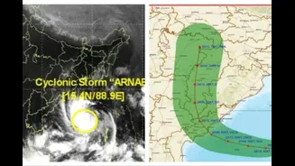
Meteorological Department (IMD) is the official and most critical source for weather forecasting. For cyclones, the IMD issues bulletins that track the storm's path, predict its intensity, and forecast its landfall location and time. Pay close attention to their colour-coded warnings, which simplify the level of threat. 'Green' means no warning, 'Yellow' advises you to be aware, 'Orange' means be prepared for adverse weather, and 'Red' is a call to action, indicating a significant threat to life and property requiring immediate safety measures. The IMD provides these updates through its official website, social media channels, and dedicated apps like 'Mausam' and 'Damini'. These alerts are the foundation for all other government agency responses.
NDMA and SDMA: The Disaster Management Framework
The National Disaster Management Authority (NDMA) and its state-level counterparts, the State Disaster Management Authorities (SDMAs), are responsible for creating the overall strategy for safety. While the IMD provides the forecast, the NDMA and SDMAs translate that forecast into actionable safety guidelines for the public. Their websites and social media feeds are essential sources for information on evacuation orders, the locations of cyclone shelters, and do's and don'ts for residents in affected areas. Each state's SDMA, headed by its Chief Minister, tailors these guidelines to the local context, making them a crucial resource for specific district-level information. Many states also operate a toll-free emergency number, such as 1070 or 1077, for disaster information.
NDRF: On-the-Ground Response
The National Disaster Response Force (NDRF) is the specialized force that conducts search, rescue, and evacuation operations on the ground. Following NDRF updates can provide a real-time picture of which areas are most affected and what the on-ground conditions are like. The force is deployed proactively to vulnerable areas before a cyclone makes landfall. Their presence and operational updates, often shared via news media and their official channels, can help you understand which routes are accessible and which are compromised. While their primary role is rescue, their movements and advisories offer practical insight into the storm's impact.
Transport Authorities: For Rail, Road, and Air
For anyone with travel bookings, transport_specific advisories are non_negotiable. Indian Railways frequently cancels, diverts, or reschedules trains in cyclone_affected regions as a precautionary measure. Passengers should check the live status of their train on the official NTES app or railway inquiry website before heading to the station. Similarly, airlines will issue advisories and often cancel flights to airports in the storm's path due to high winds and poor visibility. Check directly with your airline for the latest information on your flight status and rebooking options. For road travel, monitor updates from local traffic police and highway authorities, who will report on waterlogged and closed roads.
Local News and Official Channels
While national bodies provide a broad overview, local sources are invaluable for granular information. Tune into regional news channels and listen to All India Radio (AIR) broadcasts, which are often mandated to provide frequent cyclone updates. Many District Collectorates and local municipal bodies now use social media platforms like X (formerly Twitter) and Facebook to issue hyper_local advisories about road closures, power outages, and relief measures. These local_level updates are often the most practical for navigating your immediate surroundings safely and making last_minute transit decisions.