





A Powerful Eye in the Sky
The collaboration, known as the NASA-ISRO Synthetic Aperture Radar (NISAR) mission, is a state-of-the-art Earth observation satellite. Launched in 2025, it is now in its science operations phase, providing an unprecedented, detailed view of our planet's
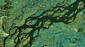
surface. At the heart of the mission is a sophisticated radar system that can see through clouds and darkness, making it uniquely suited to monitor flood-prone regions, especially during the heavy cloud cover of the monsoon season. Recent images captured by NISAR of the Brahmaputra river during the 2026 Assam floods have already demonstrated its remarkable capability to map the extent of inundation with incredible detail.
How Dual-Frequency Radar Works
What makes NISAR a game-changer is that it's the first satellite to use two different radar frequencies simultaneously—the L-band (provided by NASA) and the S-band (provided by ISRO). This dual-frequency approach works like having two types of vision at once. The longer wavelength L-band can penetrate through dense forest canopies and vegetation to detect water on the ground, which is often hidden from other satellites. The S-band is excellent for observing cropland and other surface details. Together, they create a comprehensive picture of how water is moving across the landscape. The radar signals bounce off the surface, and by analyzing the return signal, scientists can distinguish between land and water with remarkable precision, even measuring changes in water level down to the centimetre.
Faster, Wider, and More Accurate Data
Before NISAR, disaster management teams relied on ground-based river gauges and weather forecasts, which can be sparse and less effective in remote areas. Optical satellites are often useless during floods because of persistent cloud cover. NISAR overcomes these challenges by scanning nearly the entire globe every 12 days, providing reliable and frequent updates. This rapid revisit time allows authorities to track the progression of a flood in near real-time. Data products from the satellite are expected to be available within hours or a couple of days after observation, giving first responders timely and actionable information for planning evacuations, positioning resources, and assessing damage. Since early July 2026, ISRO has begun making this valuable S-band data publicly available through its Bhoonidhi portal, empowering researchers and agencies across the country.
A Partnership for a Safer Future
The NISAR mission, a $1.5 billion joint venture, is more than just a technological marvel; it represents a significant milestone in the strategic partnership between the United States and India. By combining their expertise and resources, NASA and ISRO have created a tool that will not only enhance India's disaster resilience but also provide critical data for global challenges like climate change, agricultural monitoring, and ecosystem health. For a country as geographically diverse and vulnerable to natural hazards as India, the ability to accurately map floods, monitor Himalayan glaciers, and understand changes in land use is invaluable. This collaboration serves as a model for how space technology can be harnessed for the benefit of people on Earth, turning satellite data into a vital instrument for saving lives and livelihoods.









