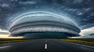


What Are These 'Cloud Walls'?
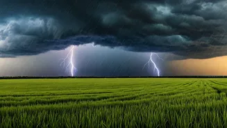
You’ve seen the videos on social media—a low, horizontal, and terrifyingly well-defined cloud that looks like a slow-motion tsunami in the sky. Meteorologists call this phenomenon an 'arcus cloud', and the most dramatic type is known as a 'shelf cloud'.
These are not separate storms themselves but are the leading edge of a large thunderstorm system. Think of them as the dramatic opening act for some very serious weather. They get their menacing, wall-like appearance because they are formed on the boundary between the cool air flowing out of a storm and the warm, moist air being drawn into it.
The Science of a Shelf Cloud
So, how does this atmospheric wall get built? It all starts with a mature thunderstorm. Inside the storm, rain and hail create powerful downdrafts—strong columns of sinking, cool air. When this downdraft hits the ground, it spreads out horizontally, like water splashing from a tap. This spreading pool of cool air is called an 'outflow boundary' or 'gust front'. As this front pushes forward, it acts like a wedge, forcing the warmer, humid air in its path to rapidly rise. When that warm, moist air is lifted, it condenses, instantly forming the distinct, shelf-like cloud we see. The turbulent, rolling look is due to the different wind speeds and directions above and below the shelf.
A Sign of Severe Weather
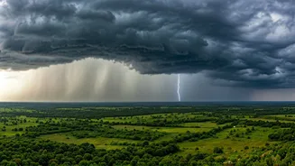
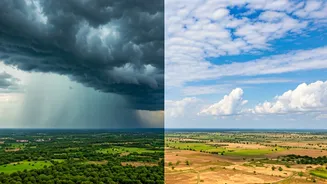
While undeniably spectacular to look at, a shelf cloud is a clear warning sign. Its arrival signals that the most intense part of the storm is right behind it. The gust front that creates the cloud can bring sudden, powerful winds, often exceeding 60-80 km/h. These winds can kick up immense amounts of dust, causing visibility to drop to near zero in a matter of seconds—a particularly dangerous situation on a busy highway. Following the wind, you can expect heavy rainfall, and sometimes even hail. The shelf cloud itself doesn't produce this weather; it’s simply the billboard announcing that the main event is about to begin.
Why Now? The Pre-Monsoon Effect
This phenomenon is particularly common during the pre-monsoon season (typically April to early June) across northern India. As the subcontinent heats up intensely, the atmosphere becomes loaded with energy and instability. The hot landmass heats the air above it, creating a perfect environment for powerful convective thunderstorms to develop. These aren't the widespread, gentler rains of the monsoon season; they are localised, violent, and fast-moving storms often referred to as 'Nor'westers' or 'Kalbaisakhi' in eastern parts of the country. The extreme temperature differences between the ground and the upper atmosphere fuel the strong updrafts and downdrafts needed to create these dramatic shelf clouds.
Safety First: What Drivers Should Do
Encountering one of these on the road can be awe-inspiring, but it demands caution. If you see a shelf cloud approaching while you are driving, the safest course of action is not to try and outrun it. Instead, find a safe place to pull over, well off the highway if possible, such as a designated rest area or an overpass. Do not park under trees, as the high winds can cause branches to fall. Turn on your hazard lights and wait for the worst of the storm—the high winds and intense rain—to pass. This usually takes about 15 to 30 minutes. Trying to drive through the low-visibility conditions created by dust and torrential rain is extremely dangerous and a leading cause of highway accidents during these events.