


What Exactly is the IMD Predicting?
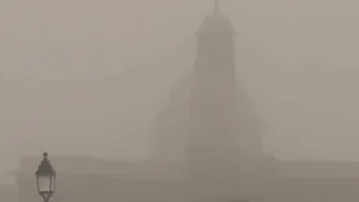
According to the latest bulletins from the IMD, a potent combination of weather systems is set to bring substantial rainfall across the northwestern plains and adjoining Himalayan regions. The forecast isn't just for light showers; it points towards a 'massive
wet spell' characterised by moderate to heavy rain, thunderstorms accompanied by lightning, and gusty winds. In some isolated areas, particularly in the higher reaches, hailstorms are also a distinct possibility. The IMD uses colour-coded alerts to indicate severity, and several states in the region have been placed under orange or yellow alerts, signalling a need for residents to 'be prepared' for disruptive weather.
Which Areas Will Be Most Affected?
The wet spell is expected to cover a vast swathe of Northwest India. The primary states in the forecast include Punjab, Haryana, Chandigarh, Delhi, and Uttar Pradesh. Additionally, significant precipitation is predicted for the western Himalayan region, encompassing Jammu and Kashmir, Ladakh, Himachal Pradesh, and Uttarakhand, where the rain could turn to snowfall at higher altitudes. Western and northern parts of Rajasthan are also likely to experience scattered rainfall and thunderstorms as the system moves across the region. Residents in major cities like Delhi-NCR, Lucknow, Chandigarh, and Amritsar should anticipate periods of intense rain that could lead to urban waterlogging.
Why Is This Happening Now?
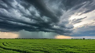
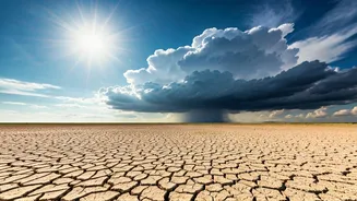
This intense weather activity is not random; it's the result of a classic meteorological interaction. The main driver is a strong, active Western Disturbance moving in from the Mediterranean region. A Western Disturbance is an extratropical storm that brings sudden winter rain and snow to the northern parts of the Indian subcontinent. What makes this event particularly potent is that this system is expected to interact with moisture-laden easterly winds blowing in from the Bay of Bengal. This confluence of a cold, upper-air system with a warm, moist, low-level wind creates the perfect recipe for instability, leading to widespread cloud cover and significant precipitation.
Potential Impacts on Daily Life
A wet spell of this magnitude can have several impacts. In urban areas, the most immediate concern is waterlogging on roads, which can cause severe traffic snarls and disrupt daily commutes. Poor visibility due to heavy rain and fog could also lead to delays in flight and train schedules. Power cuts may become more frequent as strong winds and falling trees can damage electricity lines. For rural areas, the timing of this rain is critical. While some rain can be beneficial, heavy downpours accompanied by hail and strong winds pose a significant threat to standing Rabi crops like wheat, mustard, and gram, which are nearing the maturation stage. Farmers are often advised to take protective measures.
How to Stay Safe and Prepared
With disruptive weather on the horizon, a few simple precautions can make a big difference. Firstly, stay updated with the latest forecasts from the IMD. Avoid travel if possible during periods of heavy rain, and if you must go out, check for traffic advisories and avoid waterlogged streets. Driving through flooded roads can damage your vehicle and is extremely dangerous. At home, ensure that drains are clear to prevent water accumulation. Secure any loose objects on balconies or rooftops that could be blown away by strong winds. It’s also wise to have an emergency kit with a torch, first-aid supplies, and charged power banks in case of an extended power outage. Finally, avoid taking shelter under trees during a thunderstorm and stay away from metal objects.