
More Than Just a Pretty Picture
On Earth, we take navigation for granted. GPS tells us where we are, and our eyes instantly process the road ahead. For a rover on Mars, things are far more complicated. There is no GPS, and the communication delay with Earth means it can't be 'driven'
in real-time. This is where 'terrain context' becomes critical. It isn’t just about seeing a rock; it’s about the mission team on Earth—and increasingly, the rover itself—understanding that rock’s size, its distance, its relationship to the sand dune next to it, and whether the ground around it is stable enough to drive on. Every image sent from Mars is a dataset, a collection of clues that helps the team build a three-dimensional understanding of the alien landscape.
The Rover's Eyes on Mars
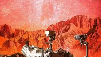
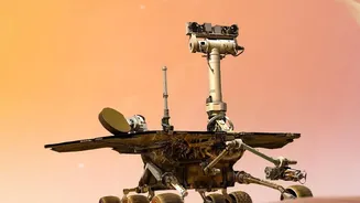
NASA's Perseverance rover is equipped with a sophisticated suite of cameras designed for this very purpose. Its primary 'eyes' for driving are the Navigation Cameras (Navcams) and Hazard Avoidance Cameras (Hazcams). These cameras work in stereo pairs, much like human eyes, to perceive depth. By taking two pictures of the same scene from slightly different angles, the rover's software can create a 3D map of the immediate surroundings. The Navcams, mounted high on the mast, provide a panoramic, 360-degree view to plan longer routes. The Hazcams, positioned lower on the rover's body, look out for more immediate dangers like large rocks or steep drop-offs directly in the vehicle's path.
From Pixels to Pathways
Turning these stereo images into a safe driving path is a process called visual odometry. The rover's software identifies distinct features in the landscape—the edge of a crater, a prominent rock—and tracks their position as it moves. By comparing the apparent motion of these features across successive images, the rover can calculate how far it has traveled and in what direction, correcting for common issues like wheel slippage on sandy slopes. This data is used by its autonomous navigation system, called AutoNav, to make real-time decisions. The rover can assess multiple potential paths, weigh the risks, and choose the safest and most efficient route toward a goal set by its human planners millions of miles away.
A Sharper Understanding of the Red Planet
The 'learning' part of the mission is a continuous evolution. With each drive, the AutoNav system gathers more data, and the engineering team on Earth refines the algorithms. Perseverance's AutoNav is a significant upgrade from previous rovers like Curiosity, featuring a dedicated computer just for image processing. This allows it to analyze terrain and make driving decisions on the fly without having to stop, dramatically increasing its speed and efficiency. Recently, the team has even started incorporating generative AI to help plan routes, analyzing orbital imagery to suggest efficient paths with key waypoints. Furthermore, a major breakthrough called Mars Global Localization now allows the rover to pinpoint its own location by comparing its ground-level panoramic images to orbital maps, effectively giving it a GPS-like ability and enabling longer autonomous drives.
Beyond Navigation: The Scientific Bonus
This rich contextual understanding isn't just for getting from Point A to Point B. The same detailed 3D maps created for navigation are a goldmine for the mission's scientists. They help the science team identify geological features worthy of closer inspection, such as rock layers that might hold clues to Mars's ancient, watery past. The images from the Navcams and Mastcam-Z provide the initial overview, helping the team triage the landscape and decide where to deploy the rover's more specialized scientific instruments. In this way, the engineering challenge of navigation directly feeds the mission's core scientific objective: searching for signs of ancient life and understanding the history of Mars.