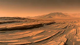


Panoramic Martian Views
The Curiosity rover, a vital part of NASA's ongoing exploration of Mars, recently sent a new panorama that is nothing short of spectacular. This composite
image offers an incredibly detailed view from the rover's location on Mount Sharp. The panorama is made up of multiple images, meticulously stitched together to create a single, comprehensive view of the surrounding terrain. It provides a unique perspective on the Martian landscape, allowing scientists and the public to examine the geology, composition, and potential history of this region. The image is a testament to the rover's capabilities and the dedication of the team behind it. This view lets us see the varied colors and textures of the Martian surface, including rock formations, the vast sky, and subtle changes in the landscape over a distance, offering crucial data points for future explorations and potential analyses.
Mount Sharp Exploration
Mount Sharp, a central feature within Gale Crater, is a key target for Curiosity's mission. The rover has been traversing the slopes of this mountain for years, collecting valuable data about its formation, the materials within it, and its environmental history. The latest panorama provides crucial context to the rover's study of Mount Sharp. Images help researchers identify different geological layers and features, allowing them to assess how they relate to each other and what they can reveal. The rover's instruments collect information to provide clues to past environmental conditions on Mars. Understanding the geological history helps the scientists assess Mars's potential to have supported past life.
Geological Features Unveiled
The panorama released by Curiosity showcases an array of geological features that are of immense interest to scientists. These images offer detailed views of rock formations, including evidence of layering and erosion patterns, revealing the planet's past. Researchers are using these images to analyze the composition of the rocks, searching for clues about the minerals present and the environmental conditions when they formed. The panoramic view allows for the identification of potential areas of interest for further study, where the rover could gather more data using its onboard instruments. Scientists can better understand the forces that have shaped the landscape. This exploration can also aid in the search for potential signs of past life, as the features give context to their presence and formation.
Implications and Future
The stunning panorama from Curiosity is not just visually appealing; it has significant scientific implications. The images and data collected help researchers understand Mars's complex geological history. The information from the rover contributes to our broader knowledge of the Red Planet and its past environmental conditions. As Curiosity continues its exploration of Mount Sharp, scientists can look forward to even more detailed data. Future missions could potentially use the findings from the Curiosity rover. Each new piece of data adds to our understanding of Mars, helping prepare for future missions, and sparking curiosity about what could be found on the planet.