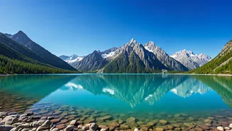


New Delhi: A geospatial analysis by Suhora Technologies documented expansion in four of five potentially dangerous glacial lakes in the Tawang district
of Arunachal Pradesh. The firm used high-resolution imagery from ICEYE, PlanetScope and ISRO, to compare the coverage of the lakes from between 2016 and 2026. The assessment focused on lakes classified by the National Disaster Management Authority in very high or high-risk categories. Overall, the lakes stored more meltwater as the glaciers retreated. Lake expansion itself does not trigger floods, but indicate that the conditions are dynamic, and requires constant monitoring.
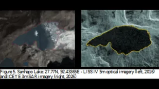
The most pronounced growth was observed in the Sanhapo Lake, that grew in area from 55.87 hectares in 2016 to 88.81 hectares by June 2026. Steady enlargement was confirmed by PlanetScope measurements from 2019 that recorded 78.07 hectares. The presence of ice at the head of the glacier in 2016 imagery complicated early measurements, but recent data has established rapid expansion. As a high-risk lake, it now presents the greatest priority for hazard modelling and early warning systems. Three lakes in the study are numbered and not named. Lake-1 grew from 20.19 hectares to 21.75 hectares over the duration of the study, while Lake-2 fluctuated slightly before reaching 13.19 hectares.
Need for continuous monitoring identified
Dharkha Tso expanded moderately from 12.40 hectares to 12.73 hectares. Lake-3 remained stable near 4.07-4.40 hectares and stayed under classification. The study highlighted the value of satellite-based monitoring in remote Himalayan terrain where field access remains limited. Such observations track lake extent, glacier retreat and landscape changes. With the monsoon season underway, continuous satellite data complements ground efforts and supports disaster preparedness and long-term climate resilience planning.
Co-founder and COO, Suhora Technologies, Amit Kumar said, “With the monsoon season approaching, continuous observation of glacial lakes becomes increasingly important and satellite-based observations can complement field investigations by providing timely information on lake expansion, glacier retreat and broader landscape changes across remote high-altitude environments. Such assessments help build long-term datasets that can support scientific research, planning and informed decision-making. Suhora Technologies remains committed to supporting government agencies, researchers and disaster management authorities with timely geospatial intelligence and Earth observation-based insights.”