
What's Happening?
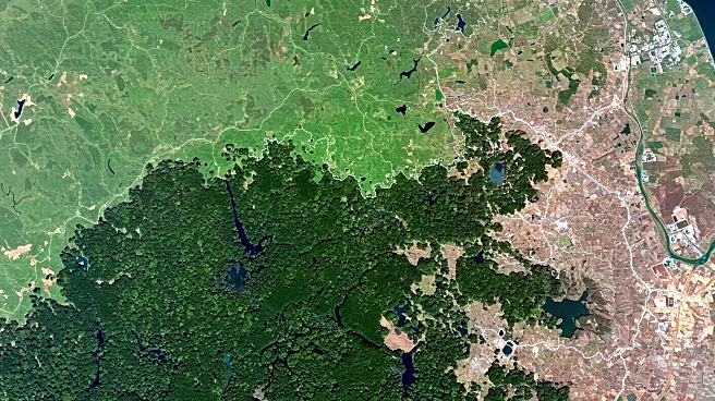
NASA's Earth Observatory has released new images showcasing the land use changes in the Santarém region of Pará, Brazil. Captured by the Operational Land Imager (OLI) on Landsat 8, these images reveal a mix of urban development, cleared pastures, farmland, and protected forests. The images, taken during the dry season on September 23, 2024, provide a clear view of the region's landscape. Santarém, a port city located at the confluence of the Amazon and Tapajós rivers, is a key distribution hub for commodities like soybeans and corn. The BR-163 highway, a major roadway in the area, connects Santarém to other urban centers and agricultural fields. The Tapajós National Forest, a conservation unit emphasizing sustainable resource use and scientific research, is also highlighted in the images.
Why It's Important?
The imagery from NASA's Earth Observatory underscores the ongoing transformation of the Amazon region, driven by agricultural expansion and urban development. These changes have significant implications for biodiversity, climate regulation, and indigenous communities. The Santarém region, with its strategic location and economic activities, plays a crucial role in Brazil's agricultural output. However, the expansion of farmland and urban areas poses challenges to conservation efforts and the sustainable management of natural resources. The images serve as a critical tool for monitoring environmental changes and informing policy decisions aimed at balancing economic growth with ecological preservation.
What's Next?
The continued monitoring of land use changes in the Amazon region is essential for understanding the long-term impacts on the environment and local communities. Stakeholders, including government agencies, environmental organizations, and local communities, may use this data to advocate for policies that promote sustainable development and conservation. Future satellite missions and technological advancements in remote sensing will enhance the ability to track these changes with greater accuracy and frequency, providing valuable insights for decision-makers.
Beyond the Headlines
The imagery highlights the complex interplay between economic development and environmental conservation in the Amazon. The region's rich biodiversity and ecological significance make it a focal point for global environmental efforts. The data from NASA's Earth Observatory can contribute to international discussions on climate change, deforestation, and sustainable land management, emphasizing the need for collaborative approaches to address these challenges.