
What's Happening?
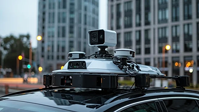
Recent advancements in mobile mapping technology have led to the development of comprehensive vehicle-mounted mobile mapping systems. These systems are equipped with multimodal sensors, including LiDAR, panoramic cameras, and GNSS/INS, to collect detailed data on urban environments. The integration of these technologies allows for precise localization and mapping, as well as support for various tasks such as object detection, semantic segmentation, and road segmentation. The MSD-VMMS-HK dataset exemplifies this progress, providing a resource for autonomous driving applications and urban planning.
Why It's Important?
The evolution of mobile mapping systems is crucial for enhancing urban planning and autonomous driving technologies. By providing detailed and accurate data, these systems enable better monitoring of urban infrastructure and facilitate the development of intelligent transportation systems. The ability to detect changes in building facilities and monitor road conditions can lead to improved safety and efficiency in urban environments. Researchers and developers can leverage these datasets to innovate and improve algorithms for vehicle localization and mapping, driving advancements in smart city initiatives.
What's Next?
The continued development and refinement of mobile mapping systems are expected to further enhance urban scene analysis. As technology advances, these systems may integrate more sophisticated sensors and algorithms, improving data accuracy and expanding their applications. Collaboration between researchers and urban planners could lead to new insights and solutions for urban challenges. Additionally, the integration of these systems with autonomous vehicles may accelerate the adoption of self-driving technology, transforming transportation and urban living.
Beyond the Headlines
The deployment of vehicle-mounted mobile mapping systems raises questions about privacy and data security. As these systems collect extensive data on urban environments, ensuring the protection of sensitive information becomes paramount. Ethical considerations regarding surveillance and data usage must be addressed to balance technological progress with individual rights. Long-term, these systems could influence urban design and policy, promoting sustainable and efficient city planning.