








With sea levels rising and a strong El Niño expected to peak this winter, parts of California's coast, major transportation routes, and even San Francisco International Airport could face an elevated risk of flooding, according to a new UC Davis report.
Drawing onrecent flooding in Southern California, researchers identified vulnerable areas across Central and Northern California that could see similar impacts if powerful storms, high tides, and elevated ocean levels converge in the coming months.
“We face the risk — though not the certainty — of catastrophic flooding in a variety of coastal towns this winter,” report author Fraser Shilling said in a statement. “It’s important to be informed of risk so you can make decisions.”
Here's what to know
about how El Niño could affect California and which areas the UC Davis report identified as high-risk this winter.
How El Nino could affect California
Gov. Gavin Newsom in late September declared a state of emergency to prepare for El Niño, mobilizing state resources and preparing infrastructure and emergency supplies ahead of time
El Niño, a naturally occurring phenomenon that warms ocean surface temperatures in the central and eastern tropical Pacific Ocean, has continued to strengthen and is expected to reach strong-to-very strong conditions from January to March, according to NOAA.
In California, El Niño can lead to "a triple threat for coastal hazards in California," according to Mark Merrifield, a director at the Scripps Institution of Oceanography, UCSD.
Those threats include rainfall-triggered landslides, coastal flooding from powerful waves that accelerate erosion, and sea level rise of 6 to 12 inches during strong El Nino conditions, Merrifield told the university in an August publication.
"Combined, these factors increase coastal erosion and flooding during El Niño events, which can threaten public parks, beaches, critical infrastructure, highways, and homes," Merrifield said.
The UC Davis report cites recent flooding in Southern California as an example of the impacts that can occur when elevated sea levels, storms, and El Niño conditions combine.
Southern California flooding may be a precursor, report suggests
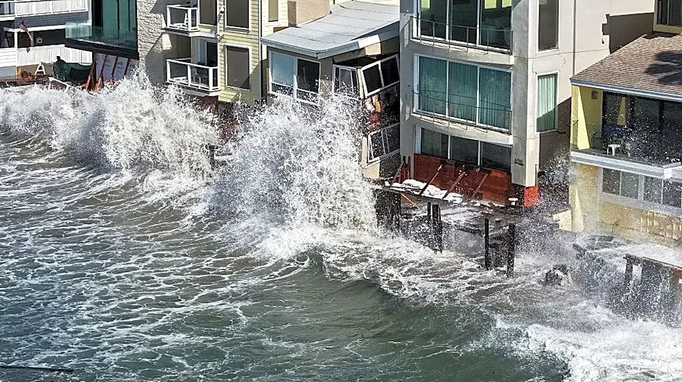
Recent hurricane systems, including Rachel and Polo, and ongoing El Niño-driven ocean conditions have generated destructive waves along the Southern California coast, leaving some communities dealing with severe flooding and damage to coastal infrastructure.

The city of Long Beach endured significant damage along Seaside Walk, the city's wooden oceanfront boardwalk on the Long Beach Peninsula, after large swells generated by Rachel and other recent hurricanes pounded the shoreline. Late last month, the city declared a local emergency in response to the "impacts from Hurricane Marie and the imminent and proximate threats of the developing 2026-27 El Niño weather pattern and winter storm season."
Meanwhile, Newport Beach also declared a local emergency earlier this month after the city’s coast and streets flooded as Tropical Storm Rachel approached the area. Video shared by the city shows fast-moving water rushing through the roadways.
The report suggests recent flooding in Long Beach and Newport Beach may preview coastal impacts that could threaten parts of Central and Northern California this winter.
Where flooding risks are highest this winter, according to report
To identify areas at risk this winter, Shilling used two coastal mapping tools to compare flooding observed in Long Beach and Newport Beach with projected sea-level-rise scenarios. The analysis found that the flooding seen in the two cities was comparable to what would be expected when water levels are about 2 to 3 feet above current sea levels.
Using these scenarios, Shilling identified vulnerable areas in Central and Northern California that are "most at risk for coastal flooding, loss of beaches, loss of shoreline houses, temporary or permanent loss of infrastructure due to erosion and flooding, and temporary or permanent alteration of coastal bluffs, marshes and mudflats."
The report highlights the following areas:
- San Luis Obispo County, including Avila Beach and Pismo Beach.
- Elkhorn Slough and Moss Landing, plus parts of the Santa Cruz coastline.
- San Francisco Bay Area, including:
- South Bay roads and residential areas
- Marshlands
- San Francisco International Airport, which sits on the low-lying shores of San Francisco Bay.
- East Bay shoreline areas
- I-80 and Bay Bridge approaches
- Marin and North Bay, including:
- Corte Madera
- San Rafael
- Highway 37 near Novato Creek, Petaluma River and Tolay Creek
- Stinson Beach
- Humboldt Bay and portions of U.S. 101
The report notes that these areas are simply examples of high-risk areas but are not the sole areas at risk.
“Whether you are an endangered species living in a marsh, a commuter on a Bay Area highway, or own a home on the shore, this winter has the risk of being the most catastrophic in recent history,” Shilling said.
These risks, however, are not new.
"All the problems we are seeing now were predicted years ago, and we should not be surprised when they start happening," Shilling wrote in his report. "There are also things we can still do and should do to minimize future risk without causing havoc on the coastline."
Instead of focusing on the aftermath of flooding, the report argues for a long-term approach that includes planning for rising sea levels and more frequent coastal flooding events.
This article originally appeared on USA TODAY: El Niño report warns of California flood risk, including SFO