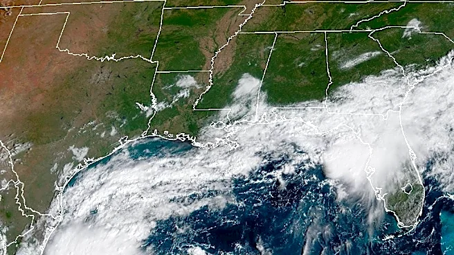








A developing system in the Gulf has a 90% chance of becoming a tropical depression or named tropical storm within the next couple of days, forecasters from the National Hurricane Center said on Oct. 6.
As the storm develops and strengthens, all outcomes remain on the table as of the morning of Oct. 6: "The storm's potential ranges anywhere from a sloppy, disorganized system to a major hurricane," said meteorologist Matt Lanza in his Substack, The Eyewall.
"The storm is already becoming better organized faster than expected, and the environment around it is becoming increasingly favorable for strengthening," said AccuWeather hurricane expert Nicholas Arman in an email to USA TODAY. "The warm waters in the Gulf will provide plenty of fuel, and winds
high in the atmosphere are lining up in a way that could help the storm strengthen more efficiently."
The next name on the list of names for 2026 is Isaias (pronounced ees-ah-EE-ahs).
Where will the storm go?
"Due to prevailing steering winds, the most likely path would be to the north-northeast toward the U.S. later this week with landfall along the central Gulf Coast this weekend," AccuWeather hurricane expert Alex DaSilva said in an online forecast.
At this time, meteorologists believe the storm is most likely to track near the panhandles of Mississippi, Alabama and Florida, as well as southeastern Louisiana.
Before the storm fully develops, the system could bring gusty winds and areas of heavy rain to the western portion of Mexico's Yucatan Peninsula, the hurricane center warned.
And regardless of development, heavy rainfall and associated flooding impacts could occur over portions of the northern Gulf Coast, the southeastern United States and Florida later this week and the weekend.

US impacts expected
Direct impacts to the United States from the storm are still several days away: "It is still too early to determine specific impacts to the northern Gulf Coast, but interests from the Florida Panhandle to Louisiana should closely monitor the progress of this system," the hurricane center warned.
At a minimum, a heavy rain and flash flood threat is all but baked in across a wide swath of the northern Gulf and into the Deep South, where double-digit rainfall totals are possible later this week and into the upcoming holiday weekend, according to WPLG-TV hurricane specialist Michael Lowry in his Substack Eye on the Tropics.
If the storm did strengthen into a hurricane, it would be the first one of the 2026 Atlantic hurricane season (although eight tropical storms have formed.) A typical season features seven hurricanes, according to NOAA.

Warm Gulf water a factor
Factors favoring tropical development include warm Gulf water temperatures in the 80s, forecasters said. In addition, disruptive wind shear is likely to be overcome by the system:
"We expect this mass of showers and thunderstorms to overcome wind shear and evolve into a tropical depression or storm," AccuWeather's DaSilva explained.

Spaghetti models for Gulf system
Could it become a hurricane?
"As this storm organizes and begins to drift north-northeastward, increasing wind shear may limit the amount of strengthening and could lead to the storm becoming distorted," DaSilva said. Still, factoring in all the variables, AccuWeather meteorologists have raised the chance that the storm could become a hurricane to 45%.
A tropical storm becomes a hurricane when its sustained winds reach 74 mph.
Contributing: Dinah Voyles Pulver, USA TODAY
Doyle Rice is a national correspondent for USA TODAY with a focus on weather and climate.
This article originally appeared on USA TODAY: Forecasters fear a hurricane is brewing in the Gulf