




Winter is coming, and that means it's time for the polar vortex to start making news. After all, what the vortex does way up there above the Arctic often eventually impacts our weather down here in the United States.
While some forecasts show that a rare early season disruption of the polar vortex (known as a "sudden stratospheric warming") could develop in early November, raising the possibility of changes to weather patterns across the U.S., it's by no means a certainty.
Those forecast models show the vortex could weaken enough for winds high above the Arctic to reverse direction, an unusual development so early in the season.
But polar vortex expert Judah Cohen of the Massachusetts Institute of Technology puts it at only a 25% probability.
Additionally,
even if it does occur, a disrupted polar vortex does not automatically mean widespread cold, snow or a sudden winter blast across the United States.
What is the polar vortex?
The polar vortex is a large circulation of cold air and strong winds in the stratosphere above the Arctic. It forms each fall as the Northern Hemisphere enters winter and the polar region loses sunlight.
Counterintuitively, a strong polar vortex makes mild weather more likely across the U.S. When it's strong, the intense cold of the polar regions stays bottled up in the Arctic.
But if disrupted by chaotic climate forces, a disturbed polar vortex can help send freezing air into the nation.
The stratospheric polar vortex is different from the jet stream and weather systems that directly influence conditions at the surface. However, changes in the vortex can sometimes influence atmospheric circulation lower down, potentially affecting the path of the jet stream and the movement of cold air.
A major "sudden stratospheric warming" (SSW) occurs when the usual westerly winds circling the Arctic at a specific stratospheric level reverse to easterly winds. Despite the name, the warming occurs high in the atmosphere, about 10 to 30 miles up.

What the latest polar vortex forecast shows
According to Cohen, the polar is stretching this week, which is bringing some colder weather to eastern North America (which is regionally confined and not impressive), but deeper and more widespread cold to Siberia and East Asia.
Weather patterns in East Asia will help to weaken the polar vortex further and more akin to a sudden stratospheric warming, he said. This is a much larger disruption of the polar vortex and the impacts to the weather can be much more long-lasting than a stretched polar vortex.
"Though I don’t rule out that it will just resolve itself into another stretched polar vortex in the end," Cohen told USA TODAY.
The potential for a reversal of the winds in early November is notable because major sudden stratospheric warmings typically occur later in the Northern Hemisphere winter.

Which models are showing a polar vortex disruption?
As of Oct. 26, the European Centre for Medium-Range Weather Forecasts, or ECMWF, was signaling the potential for an unusually early disruption of the Arctic polar vortex.
According to the Polar Vortex Earth monitoring site, 18 of 50 ECMWF ensemble forecasts showed winds around the pole reversing from westerly to easterly by Nov. 9. That amounts to a 36% chance in that model's ensemble.
The monitoring site said its historical record, which begins in 1959, contains no major sudden stratospheric warming before Nov. 28. The earliest events in that record occurred in 1968 and last year, when blizzard conditions and winter storm warnings hit the Great Lakes over Thanksgiving.
The forecast also shows the vortex stretching dramatically around Nov. 2, becoming about 2.84 times as long as it is wide. The monitor places that forecast shape above the 95th percentile for the date compared with 1991-2020.
These are model projections, not confirmation that a major warming or wind reversal will occur.
How (and when) will all this impact the weather in the US?
"This is the $64,000 question!" Cohen told USA TODAY. "I think the most certain impact is to bring a period of milder weather to eastern North America, probably for much of November. Usually it takes two weeks (but recently it seems to take much longer) for the impacts of the SSW to impact our weather so that puts it as early as late November but more likely in December and could even be delayed until January."
"The downward influence of the SSW in my opinion is more likely to impact the weather of Northern Europe and/or Northern Asia than the eastern US. SSWs have been to be related to colder temperatures and heavier snowfall across Northern Eurasia but also the Eastern US.
"Though recently, the impacts from SSWs in the eastern US have been heavily skewed to resulting in overall milder weather across the eastern US, in stark contrast to expectations. The last El Niño in 2023-24 featured two SSWs and it was a very mild winter in the eastern US and may have even been record mild. In short lots of uncertainty!"
Could the polar vortex affect US weather by late November?
A disruption in early November could influence surface weather later in the month if the changes descend through the atmosphere and affect broader circulation patterns.
The Polar Vortex Earth monitor says these changes can take roughly two to six weeks to work downward. That timing puts late November and early winter within a possible window for impacts, but it does not establish that a particular region will turn colder or experience snow.
Even when the polar vortex weakens or a major sudden stratospheric warming occurs, the resulting weather patterns vary. Some areas can experience colder conditions while others remain mild. The location and persistence of any cold air depend on how the atmosphere responds.
In late October, especially this year as above-normal temperatures persist, there is the issue of a limited immediate cold-air supply: Severe Weather Europe cautioned that, unlike in midwinter, the available cold air in late October is still limited. The disruption could increase the chance of a cool wave, but it does not guarantee a widespread cold outbreak.
For now, the forecast does not support promising a nationwide cold snap or a specific snow event.
What NOAA's latest November outlook says
The National Oceanic and Atmospheric Administration's Climate Prediction Center currently favors above-average temperatures across much of the contiguous United States and Alaska from Nov. 7-20.
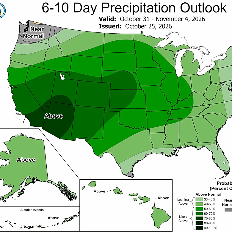
Its Week 3-4 outlook, issued Oct. 23, shows the strongest probabilities for above-average temperatures along the southern California coast. The outlook also favors above-average precipitation in parts of the Pacific Northwest, West Coast and Southwest, while precipitation signals are mixed across the Southern Plains.
The outlook does not attribute those conditions to a polar vortex disruption. It is a separate forecast based on broader atmospheric patterns and other climate signals, including a strengthening El Niño.
The temperature outlook also covers the first part of November's second and third weeks, not the entire month. A potential stratospheric disruption could evolve after that forecast period, but there is not yet enough certainty to say how it would affect temperatures later in November.
Doyle Rice is a national correspondent for USA TODAY, with a focus on weather and climate. Brandi D. Addison covers weather nationwide as the Weather Connect reporter for the USA TODAY Network.
This article originally appeared on USA TODAY: Polar vortex is stirring and could soon disrupt our weather. What to know