






Texas has had no shortage of heat this summer.
Across the state, prolonged stretches of triple-digit temperatures and oppressive heat have made for a decidedly different summer than last year.
From the Panhandle to South Texas and from the Gulf Coast to North Texas, communities have endured repeated stretches of temperatures near or above 100 degrees, with some areas also experiencing dangerous heat indexes. And in parts of South Texas, temperatures have remained near 100 degrees even after the calendar turned to September.
There is good news: While Texas could certainly see another 100-degree day before the calendar year ends, historical data suggest such days are increasingly anomalies rather than the start of another prolonged stretch of extreme
heat. For much of the state, the frequency and duration of triple-digit temperatures typically decline as September continues.
So, when can Texans typically expect their final 100-degree day? Here's what the historical record shows.
Is the Texas heat finally coming to an end?
Not necessarily — at least not yet.
September can still be a very hot month in Texas, particularly across the southern half of the state. Historically, the transition to consistently cooler weather happens gradually, with the first meaningful cold fronts typically arriving later in the fall.
This year, the Climate Prediction Center is favoring above-normal temperatures across much of the western and central United States for September through November.
That doesn't mean Texas will stay in the triple digits all fall. Above-normal temperatures simply mean temperatures are expected to run warmer than the historical average more often than not.
But for Texans hoping for an immediate end to summer-like weather, September isn't necessarily the finish line.
Why has Texas been so hot?
One of the biggest players this summer has been a recurring high-pressure pattern, sometimes called a heat dome, that has suppressed clouds and rainfall and allowed temperatures to climb.
High pressure also promotes sinking air, which warms as it descends. When that pattern persists for days or weeks, the heat can build — particularly when nighttime temperatures remain elevated, offering little opportunity for people, buildings and infrastructure to cool down.
The broader atmospheric pattern has also favored above-normal temperatures across much of the southern and central United States. The Climate Prediction Center said in August that El Niño was strengthening and forecast a greater-than-90 % chance of a very strong event during the fall and winter.
Interestingly, El Niño doesn't have a simple one-to-one relationship with Texas summer temperatures. Its more recognizable influence on Texas tends to emerge later in the year, when it can favor cooler and wetter conditions during the late fall and winter.
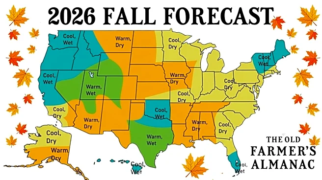
Old Farmers' Almanac fall forecast for Texas
The Old Farmer’s Almanac is calling for a warmer and drier start to fall across much of Texas, though conditions vary by region. The state's northern and western areas fall within the Almanac's warmer, drier High Plains and Desert Southwest outlooks, while parts of East and Central Texas fall within the Deep South and Heartland regions, where temperatures may vary more through the season.
For September and October, that generally points to continued warmth and limited rainfall across much of Texas, with some areas potentially seeing a brief shift toward cooler conditions later in the fall.

When do temperatures normally cool down in Texas?
Across most of Texas, temperatures finally begin to cool in October, with average highs finally dipping below the triple-digit mark.
Here’s a look at the earliest, latest and average last 100-degree day recorded across the state since 1940, according to data from the National Weather Service.
Austin
- Earliest: June 13 (1942)
- Latest: Oct. 13 (2024)
- Average: Aug. 24
Amarillo
- Earliest: June 14 (2004)
- Latest: Sept. 19 (2024)
- Average: Aug. 5
Corpus
- Earliest: April 23 (1955)
- Latest: Oct. 17 (2012)
- Average: Aug. 29
Dallas-Fort Worth
- Earliest: July 13 (2004)
- Latest: Oct. 3 (1951)
- Average: Aug. 29
El Paso
- Earliest: June 18 (1941)
- Latest: Sept. 27 (2024)
- Average: Aug. 11
Houston
- Earliest: June 13 (2006)
- Latest: Sept. 27 (2005)
- Average: Aug. 15
Lubbock
- Earliest: May 11 (1962)
- Latest: Oct. 3 (2000)
- Average: Aug. 2
Midland-Odessa
- Earliest: June 9 (1988)
- Latest: Oct. 8 (1979)
- Average: Aug. 21
San Antonio
- Earliest: July 4 (1970)
- Latest: Oct. 4 (2023)
- Average: Aug. 26
Tyler
- Earliest: July 12 (1955)
- Latest: Sept. 26 (2005)
- Average: Aug. 21
Waco
- Earliest: July 22 (1971)
- Latest: Oct. 15 (2024)
- Average: Aug. 31
Wichita Falls
- Earliest: June 27 (1950)
- Latest: Oct. 17 (1972)
- Average: Sept. 5
Brandi D. Addison covers weather across the nation as the Weather Connect reporter for the USA TODAY Network and contributes to Texas Connect coverage across the state. She can be reached at baddison@usatodayco.com. Follow her on Facebook here.
This article originally appeared on USA TODAY: How long will it be hot in Texas? When triple-digit temps usually end