

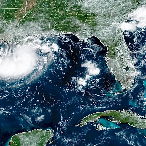




The National Weather Service has issued a tropical storm and flood warning for the Houston and Galveston areas as Texas prepares for the storm's impact.
While the warning was issued on Aug. 31, Texas Gov. Greg Abbott said in a social media post on Aug. 30 that Texas is monitoring the tropical storm in the Gulf set to impact the Houston area.
"We are already coordinating with electric power providers," Abbott said on social media. "If the system continues to develop, we will make announcements about emergency preparation, as needed."
The Texas Division of Emergency Management is also advising people to listen to local officials as the conditions develop and warnings are issued.
Here's what we know about the tropical storm and how to stay safe.
Tropical storm warning hits Texas

Bolivar,
Crystal Beach and High Island have been placed under a Tropical Storm Warning by the weather service because the storm poses a threat to life and property.
As of a 10:10 a.m. warning notice on Aug. 31, the impact of wind is forecast to be limited, with 15-20 mph winds and gusts up to 40 mph and conditions being unfavorable for tornadoes. Storm surge is forecast to be limited, with localized storm surge possible up to two feet.
The real threat comes from flooding rains, as "moderate rainfall flooding may prompt several evacuations and rescues," along with some road and bridge closures.
"Rivers and tributaries may quickly become swollen with swifter currents and overspill their banks in a few places, especially in usually vulnerable spots," read the warning. "Small streams, creeks, canals, and ditches overflow."
The weather service is advising people to heed any flood watches and warnings, leave immediately if evacuation orders are given and prepare now should conditions become hazardous.
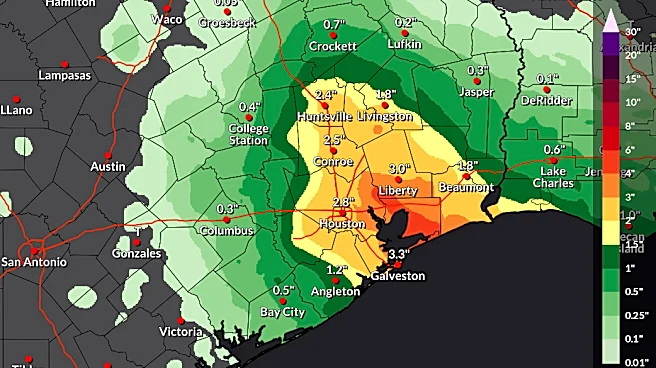
Houston-area forecasted to see up to 9 inches from tropical storm
The weather service placed Galveston and Houston under a flood warning until Wednesday morning, as periods of moderate to heavy rainfall associated with Potential Tropical Cyclone Five are expected to begin as early as late tonight and last into late Tuesday night/early Wednesday morning.
"3-5 inches with isolated amounts of 6-9 inches are expected with the highest totals occurring east of I-45," the warning stated. "Rainfall rates will exceed 3-4 inches per hour at times in the heaviest downpours, which can lead to flash flooding especially in urban and vulnerable areas."
The weather service advises residents to monitor later forecasts and watch for possible Flood Warnings; those living in areas prone to flooding should be prepared to act if flooding develops.
Tropical storm safety tips
The Texas Division of Emergency Management advises those experiencing a hurricane or tropical storm to do the following to stay safe:
- If local officials say to evacuate, do so immediately.
- Determine how best to protect yourself from high winds and flooding.
- Take refuge in a designated storm shelter or an interior room for high winds.
- Go to the highest level of the building if you are trapped by flooding. Do not climb into a closed attic as you may become trapped by rising flood water.
- Do not walk, swim or drive through flood waters.
- Remember: "Turn around. Don't drown," as just six inches of fast-moving water can knock people down, and one foot of moving water can sweep away a vehicle.
Spaghetti models for Potential Tropical Cyclone 5. See expected path
Special note about spaghetti models: Spaghetti model illustrations include an array of forecast tools and models, and not all are created equal. The Hurricane Center uses only the top four or five highest performing models to help make its forecasts.
Stay informed. Get weather alerts via text
Mateo Rosiles is the Texas Connect reporter for USA TODAY and its regional papers in Texas. Got a news tip for him? Email him at mrosiles@usatodayco.com.
This article originally appeared on USA TODAY: Texas braces for potential tropical storm. See spaghetti models