



Although the peak of hurricane season is still about a month away, both the Atlantic and Pacific basins are becoming active as the calendar reaches mid-August.
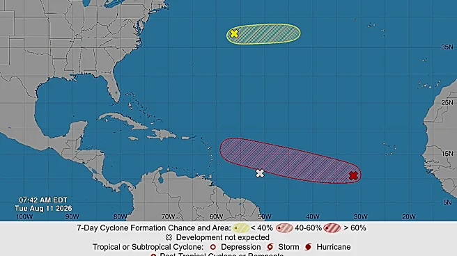
A developing system in the Atlantic could become Cristobal in the next few days, which would be the third named storm of the 2026 Atlantic hurricane season. Its future track and intensity remain uncertain as of the morning of Aug. 11.
Still much closer to Africa than the Americas, what could be Cristobal remains in the early stages of development. "Environmental conditions are forecast to become more conducive for development during the next couple of days, and a tropical depression will likely form during the latter half of this week while the system moves westward to west-northwestward
across the central tropical Atlantic," the National Hurricane Center said in an Aug. 11 online forecast.
But forecasters see some hints about the future of the system in early model runs.
Models are split on whether the system stays weak and tracks into the Caribbean or over parts of the Lesser Antilles and Puerto Rico and the Virgin Islands by Sunday, Aug. 16 into Monday, Aug. 17, or manages to thread a needle, curving north of the islands into the open central Atlantic while strengthening into early next week, according to Michael Lowry, a hurricane specialist with WPLG-TV in Miami.
"The majority of model solutions favor the weaker and southern track for now (near or through the easternmost Caribbean islands late this weekend into early next week), and given the blistering firehose of wind shear over the Caribbean, it’s unlikely the system would survive much into next week if it did develop," Lowry wrote in an Aug. 11 Substack post.
In Puerto Rico on Aug. 11, the National Weather Service warned it's "too early to determine what impacts, if any, this system could bring to Puerto Rico or the U.S. Virgin Islands."
Meanwhile, in the Pacific, a system could become Lala this week and potentially impact portions of Hawaii by the weekend.

Map tracks the path of developing storms
Hurricane safety tips
With the season heating up in both basins, this is a good time to review hurricane safety tips. According to the weather service, the two biggest hurricane killers are storm surge and inland flooding, so it's a good idea to "know your evacuation zone, heed evacuation orders, and never drive through flooded roads." Several storm-related deaths in 2026 have been attributed to vehicles driving over flooded roads.
In addition, the National Oceanic and Atmospheric Administration advises folks to gather an emergency kit that includes at least three days of water (1 gallon per person per day), nonperishable food, medications, flashlights, batteries, cash and a battery-powered or hand-crank weather radio.
Also, NOAA advises people to have multiple ways to receive warnings and not rely solely on their phones, such as weather radios, emergency alerts, TV, radio and trusted weather apps.
Doyle Rice and Dinah Voyles Pulver are national correspondents with USA TODAY, specializing in weather and climate. Reach Rice at drice@usatoday.com and Pulver at dpulver@usatoday.com
This article originally appeared on USA TODAY: Hurricane forecasters expect Cristobal to form. Will it head for US?