
More than 32 million people across the Mid-Atlantic are facing a threat of flash flooding Thursday as thunderstorms develop and move toward the East Coast, with New York City, Philadelphia, Baltimore and surrounding
communities among the areas that could see the heaviest rain.
The storms also could produce damaging wind gusts and a couple of tornadoes, according to the National Weather Service Storm Prediction Center.
What are the greatest risks for severe weather?
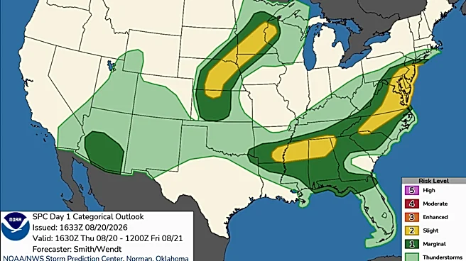
The flooding threat comes with an additional concern: some storms could become severe. The Storm Prediction Center has placed parts of the Mid-Atlantic under a slight risk of severe thunderstorms.
Forecasters say storms could produce:
- Damaging wind gusts
- A couple of tornadoes
- Frequent lightning
- Torrential rainfall
- Flash flooding
Storms may initially develop as individual supercells before merging into a line as they move east.

Where is flash flooding possible?
The greatest concern is along and near the Interstate 95 corridor, including:
- New York City: Heavy rain and thunderstorms are possible late Thursday afternoon and evening, with locally higher rainfall amounts and intense rainfall rates capable of causing flash flooding, particularly in urban areas.
- Philadelphia: Periods of heavy rain and thunderstorms could produce flooding in low-lying and poor-drainage areas.
- Baltimore: Strong thunderstorms could bring heavy rain, damaging winds and an isolated tornado.
- Washington, D.C.: Storms moving through the region could produce intense rainfall and localized flooding.
- New Jersey: Parts of the state could see heavy rainfall as storms move east toward the coast.
- Southeastern Pennsylvania and Delaware: Flooding is possible where thunderstorms repeatedly track over the same locations.
When will storms hit?
Storms are expected to become more numerous during the afternoon and evening Thursday, with the most significant activity shifting east toward the coast later in the day, according to the Storm Prediction Center.
For the New York City area, the National Weather Service says showers and thunderstorms are expected to move through late Thursday afternoon into the evening.
That timing could overlap with the evening commute, increasing the potential for traffic problems and dangerous travel.
How much rain could fall?
Rainfall amounts will vary considerably because thunderstorms can produce very different totals over short distances. Forecasters say 0.5 to 1 inch of rain is possible, with locally higher amounts near 3 inches.
The bigger concern is how quickly the rain falls. Some thunderstorms could produce rainfall rates of 1 to 2 inches per hour, which can overwhelm storm drains and cause rapid water rises.
Why can flash flooding happen so quickly?
Thunderstorms can dump several inches of rain over a small area in a short period of time.
That becomes particularly dangerous in cities, where roads, parking lots and buildings prevent rain from soaking into the ground.
Areas that commonly flood — including underpasses, low-water crossings, creek beds and poorly drained streets — can become dangerous quickly.
What should you do?
If you're in the threat area Thursday:
- Don't wait until water is covering a road to turn around. Find another route before conditions deteriorate.
- Avoid flooded underpasses and low-lying roads. Water depth can be difficult to judge, especially at night.
- Keep an eye on weather alerts. A severe thunderstorm or flash flood warning means conditions are occurring or imminent, not merely possible.
- Move indoors when thunder is heard. Lightning can strike well outside the immediate area of heavy rain.
- If a tornado warning is issued, shelter immediately. Move to an interior room on the lowest floor of a sturdy building and stay away from windows.
- Don't drive through floodwater. Water can conceal washed-out roads, debris or other hazards.
- Give yourself extra travel time. Heavy rain can sharply reduce visibility and create dangerous road conditions even before flooding begins.
The severe weather threat extends beyond the Northeast. Strong thunderstorms are also possible Thursday across the Carolinas, Tennessee Valley, Deep South and from the central Plains into the Upper Mississippi Valley.
Farther north, storms from Nebraska into Wisconsin could produce large to very large hail and wind gusts of 55 to 75 mph. The storm threat will continue shifting east through the evening as the system moves toward the coast.
U.S. weather watches and warnings map
Stay informed. Get weather alerts via text
Brandi D. Addison covers weather across the nation as the Weather Connect reporter for the USA TODAY Network and contributes to Texas Connect coverage across the state. She can be reached at baddison@usatodayco.com. Follow her on Facebook here.
This article originally appeared on USA TODAY: Flash flooding threat targets 32M including NYC, Philadelphia