






One of the earliest snow events of the season is forecast to unfold in the highest elevations of the Colorado Rockies, forecasters from the National Weather Service said.
The snow will be a small part of a major late September/early October storm
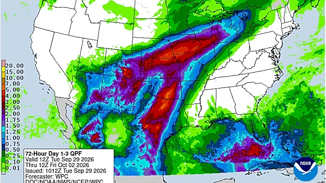
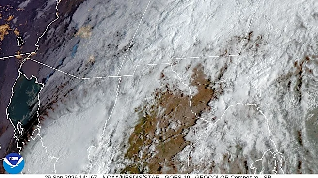
that's forecast to bring boatloads of rain to the Southwest and central United States. The storm is due partly to the remnants of Hurricane Polo, which is now battering the west coast of Mexico."Pacific tropical moisture will wrap into a storm over the southwest U.S. and will continue a multi-day heavy rainfall event this week that will extend into the Midwest and southern Plains," the weather service said.
The system was called a "hybrid storm" by AccuWeather meteorologist Alyssa Glenny because the system combines
the remnants of Hurricane Polo with a separate, sprawling weather system. It's expected to bring days of rain and possible flooding across a large section of the central United States.
Storm coming together
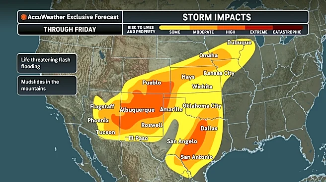
The storm, which is still coming together Tuesday, Sept. 29, is forecast to bring heavy rain and considerable flooding from Arizona to Chicago over the next few days.
"A major flood event is unfolding across the southwestern and central United States as residual tropical moisture from two hurricanes clashes with another storm swinging in from the west," Glenny said. She added that this weather event comes just days after some areas of the Southwest were saturated by heavy rain, resulting in an even higher risk of flash flooding.
"In some places, especially in New Mexico, this may be the most dangerous flash flooding risk in the last 5 years or more," AccuWeather chief meteorologist Jon Porter said.

Snow level forecast
In the West, snow forecasts typically mention the snow level, which is the elevation above which snow starts to fall. The higher the snow levels, the fewer people are usually affected.
In this storm, snow levels look to be above 11,000 feet, so only lightly populated areas should see snow. Most of the state, including the Denver metro area, will see plain rain.
"Snow chances in the higher terrain will peak early Thursday morning [Oct. 1] as temperatures finally start to cool more aloft," the weather service in Denver said in an online forecast discussion on Sept. 29. "Amounts are still forecast to be on the lower end (a couple inches at most), with snow levels generally around 11,000 feet.
Further south in southern Colorado, the weather service in Pueblo said that "snow levels look to remain high; above 12,000 feet through this period. Several inches of snow are possible across the higher peaks."

Up to 8 inches of snow possible?
The weather service issues maps that show the high-end snowfall forecast, meaning the maximum amount of snow that could fall during the storm. Maps from the weather service in Pueblo show that up to 8 inches could fall in the Sangre de Cristo Mountains, near Westcliffe and south of La Veta Pass toward Trinidad.
Similar maps from the weather service in Denver also show some spots west of the city could pick up to 8 inches in a high-end scenario.
How about road conditions?
According tothe Autoblog, snow could cause some driving headaches for folks in southern Colorado during the storm.: "Monarch, Wolf Creek and La Veta passes all fall inside the shaded areas on the Pueblo map."
"Wet snow on those passes is most likely to turn icy overnight and early in the morning, and shaded switchbacks are the last stretches to clear once the sun comes up," the Autoblog said.
Doyle Rice is a national correspondent for USA TODAY, with a focus on weather and climate.
This article originally appeared on USA TODAY: 'Hybrid storm' may dump 8 inches of snow, forecast says. Here's where