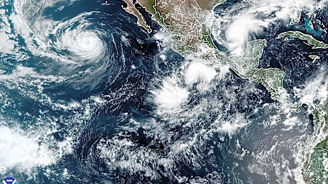








Under the influence of a strengthening El Niño, the eastern Pacific continues to crank out tropical systems.
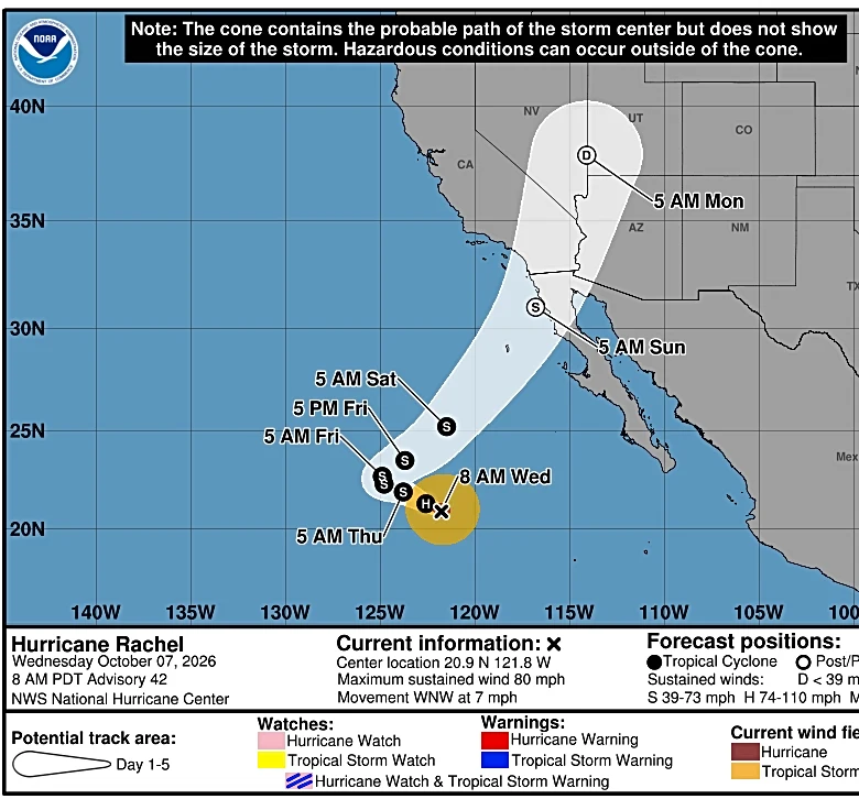
Hurricane Rachel is forecast to disintegrate, but bring rain to the northern coast of Baja California Sur and Southern California over the Oct. 10-11 weekend.
Southern California is within the hurricane center's cone forecast graphic for the movement of Rachel's dissipating center as a post-tropical storm. But the National Weather Service regional forecast explains that moisture from Rachel will be absorbed into a different low pressure system expected to form off the coast, and then move northeastward.
Meanwhile, a new tropical depression, Twenty-E, formed on Oct. 7, the National Hurricane Center said. It's the 22nd storm in the eastern
and central Pacific since hurricane season started on May 15.

Rachel to impact Southern California
The forecast may prove to be a bit of good news, bringing at least a temporary reduction in the blazing hot temperatures baking the region. Rain associated with the remnants is forecast to move into Arizona and Nevada over the weekend, and then into Utah on the morning of Oct. 12.
Some of the weather models are showing a fairly strong low pressure system that could also generate strong onshore winds that could lead to more significant coastal flooding, Daniel Swain, a climate scientist with the University of California Agriculture and Natural Resources, said in a social media post on Oct. 7.
Tropical Depression Twenty-E
The latest tropical system off Mexico in the Pacific is forecast to become a hurricane by Oct. 9, the hurricane center said.
Since the storm will be in an environment of low wind shear, abundant moisture and very warm sea surface temperatures, steady strengthening is forecast, Richard Pasch, a senior hurricane specialist at the hurricane center, wrote in a forecast update.
On Oct. 7, the depression had sustained winds of 35 mph and was centered about 285 miles south-southeast of Lazaro Cardenas and about 405 miles southeast of Manzanillo. The forecast track calls for it to move northward, skirting close to the coast.

Heat wave drones on
In the midst of the heat wave, several weather stations in Southern California set new maximum high temperature records on Oct. 6, according to the National Weather Service.
The new records include:
105: Escondido, breaking a record of 99, set in 1953 and 1893.
101: Vista, breaking a 99-degree record set in 1971 and 1957, and Ramona, breaking a 99-degree record set in 2024 and 1974.
100: Anaheim, breaking a 99-degree record set in 2005 and 1989.
Record warm sea surface temperatures
Far to the south of California, the El Niño 3.4 region of the Pacific Ocean continues its run in the record books.
Average daily ocean temperatures in the region again topped a record this week, hitting 86 degrees, (30-degrees Celsius), according to the University of Maine's Climate Reanalyzer.
Water temperature anomalies in the region are now warmer than during any other previous El Niño on record, Zeke Hausfather, a climate scientist at Berkeley Earth, posted on social media this week.That's higher than records set in 2015 and 1877, he said.
Dinah Voyles Pulver covers climate change, weather and the environment for USA TODAY. Reach her at dpulver@usatoday.com or @dinahvp on Bluesky or X or dinahvp.77 on Signal.
This article originally appeared on USA TODAY: Tropical storm will turn toward Southern California, forecasters say