






Forecasters on Sept. 14 were monitoring a disturbance in the central Atlantic for development amid what has been a historically slow hurricane season.
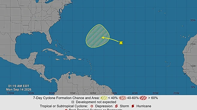
The trough of low pressure, which is located 1,000 miles east-southeast of Bermuda, is producing disorganized showers and thunderstorms, according to the National Hurricane Center.
Forecasters say the disturbance is facing strong winds that could hinder its development over the next several days. As the system continues to move west, it's forecast to enter an area more conducive to "gradual development," according to the hurricane center.
The system likely won't develop over the next 48 hours. It has a 30% chance of forming into a tropical depression or tropical storm over the next week, the hurricane
center said.

The system is one of several disturbances that cropped up in recent days, though most have since dissipated, including Tropical Storm Cristobal, which quickly lost strength as it moved away from the United States and into open water.
This hurricane season has been markedly quiet due to the strength of El Niño, which has suppressed the formation and organization of major storms. So far in the 2026 season, which runs from June 1 through November 30, no hurricane has formed, setting a new record for the latest date in a modern hurricane season without at least one hurricane.
While the season is less busy than normal in the Atlantic, the Pacific is seeing a much busier year because of the changing conditions from El Niño. At least two storms are being monitored there, including Tropical Storm Norbert, which formed on Sept. 10 and is located over 1,000 miles east of Hawaii.
Contributing: Dinah Voyles Pulver and Doyle Rice
This article originally appeared on USA TODAY: Forecasters tracking new disturbance in the Atlantic. Will it develop?