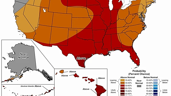








For some parts of the country, the official start of fall will coincide with cooler temperatures – a welcome reprieve from a summer of sweltering heat waves and record temperatures.
Some areas are already enjoying mild temperatures
well off their summer highs. Cities across the Northeast, including New York, Boston and Philadelphia, have experienced a stretch of autumn-like weather in mid-September, with overnight lows in the 50s and 60s.The trend is likely to continue, forecasters say, as the Northern Hemisphere loses daylight and summer loosens its grip on large parts of the country.
"The most intense heat of the season is pretty much finished," said Chad Merrill, senior meteorologist and long-range forecaster at AccuWeather. "There will be
some periods of warmer-than-average temperatures ... but we're starting to see signs of fall."

But not all parts of the U.S. are relishing cooler temperatures. Across the central and southern U.S., temperatures have remained above average for weeks, with afternoon highs well into the 90s and, in some areas, triple-digits.
On Sept. 17, heat advisories were active from Oklahoma to Illinois. And in Tennessee, feels-like temperatures were expected to reach over 100 degrees.
Meteorologists say the relentless heat will soon begin to lose intensity, especially as El Niño brings bouts of rain to the drought-stricken central U.S.
"This massive heat dome looks like it's starting to break down," Merrill said.
It's starting to feel like fall (in some areas)
The current stretch of weather throughout the Northeast, mid-Atlantic and Great Lakes regions stems from an area of low pressure that's driving cooler air from Canada across a large swath of the country. The system is also causing low humidity.

Cities such as Chicago, Boston and New York have seen low temperatures in the 50s and 60s in recent days. Many of the same areas suffered intense heat domes over the summer, including a record-breaking heat wave over Independence Day weekend that killed more than 30 people, authorities say.
The crisp temperatures are expected to persist for several days before temperatures begin climbing back up, said Anthony Artusa, a meteorologist at the National Weather Service's Climate Prediction Center.
He said temperatures commonly fluctuate during the early fall season, but grow colder over time.
"It's almost like a step, where it goes back and forth," he said, adding that temperatures are expected to hover above average but remain below their summer highs.
"For most of the country, I don't think we have to worry about really intense heat domes at this point," he said. This is particularly true for states in the Northern Hemisphere, as nights become longer.
"It's a lot harder to maintain high-heat environments as we move into October," he said.
Frost advisories issued in multiple states
Authorities in at least five states issued frost advisories in mid-September, representing some of the first cold-temperature warnings ahead of the fall season.
The advisories were issued across parts of Vermont, Idaho, Maine, Minnesota and North Dakota. Some of the low temperatures forecast in these states dipped into the 30s, according to the weather service.
By Sept. 17, the advisories had largely expired. Forecasters described them as a signal that frigid temperatures are quickly approaching in some areas.
Looking ahead, Merrill said a cold front could move through the Northeast in late September and early October and drop temperatures across the region to near-freezing levels overnight, especially in mountainous areas.
"The airmass could be cold enough, perhaps, to produce a couple of snowflakes in the highest elevation areas," he said.
Long-range forecasts for the upcoming winter are particularly tough to pin down because of the strengthening El Niño, a natural warming of seawater in the Pacific Ocean, and its interactions with the polar vortex. If El Niño disrupts the polar vortex, it can lead to extreme cold in the eastern U.S., experts say.
Heat persists across south-central US

For weeks, much of the center of the country has remained in the grip of a sweltering heat dome that has driven temperatures well above average.
Forecasters say the intense heat cooking the Mississippi Valley and southern Plains regions will cool down over the coming weeks as showers and thunderstorms move into the area.
"We're going to see this heat dome start to get chipped away at," Merrill said.
He noted that St. Louis, Missouri, has experienced its second-warmest start to September since the late 1800s. The city is one of several metro areas – including Dallas, Oklahoma City and Austin – that have recorded far more 100-degree days than usual for this time of year, according to AccuWeather.
But while cooler temperatures are on the horizon, the sweltering heat is expected to persist for some time.
"The hazardous heat is here to stay this week across the South," the weather service said in a Sept. 17 outlook. "In fact, high temperatures reaching into the upper 90s to lower 100s will challenge daily records from the Southern Plains to the lower Mississippi Valley where Heat Advisories remain in effect."
Contributing: Doyle Rice and Dinah Voyles Pulver
This article originally appeared on USA TODAY: Late September forecast calls for 'signs of fall,' milder temperatures