




A nor'easter is forecast to form later in the week of Nov. 9 and potentially bring the season's first snowfall to millions across the northeastern U.S., meteorologists predict.
"After a relatively warm stretch of weather from late October through early November across a majority of the Midwest and Northeast, a shifting weather pattern will bring a sharp turn towards cooler conditions later this week," said AccuWeather meteorologist Brandon Buckingham, in an online forecast. "In addition to the chill, a storm later this week can bring the potential for the first snowfall of the season for many."
There is still uncertainty in the track and expected impacts from the storm, NOAA's Weather Prediction Center said, but there has been a trend for the heavier
rainfall to be over the northern Mid-Atlantic and early season snow possible for the higher terrain of the Appalachians, especially Pennsylvania and West Virginia.
The developing system is expected to spread widespread rain across the East,Fox Weather said. The big cities of the Northeast and Mid-Atlantic should mainly see a cold rain from the storm.
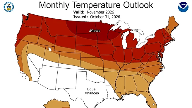
Fortunately, for mild weather lovers in the East, the cold snap should be short-lived, as temperatures are forecast to return to above-average levels by next week, according to NOAA's Climate Prediction Center. Overall, the nation is forecast to see one of its top 10 warmest Novembers on record.

Where is snow most likely?
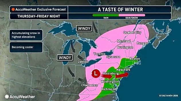
There will be many pieces to this storm that will have to come together later this week, but at this time, it looks likely that some locations from the Great Lakes, Ohio Valley, the Appalachians and New England could face the potential for snow between Thursday (Nov. 12) and Saturday (Nov. 14) as the storm intensifies and slowly tracks through the regions, according toAccuWeather.
"Locations that could face their first snowflakes of the season include Pittsburgh, Pennsylvania, and Syracuse and Binghamton, New York. The mountainous terrain of the Poconos, Catskills and Berkshires will also face the risk of snow," Buckingham said.
As for when it's expected to begin, "by Thursday [Nov. 12] night, we should start to see the first chances of snow across interior regions of the Northeast," Weather.com meteorologist Rob Shackelford said in an online forecast.
At this time, conditions are expected to be too warm for the first snowflakes of the season in places like Washington, D.C., Philadelphia, New York City and Boston later this week due to the influence of the warmer Atlantic Ocean nearby.
Some lake effect rain and snow showers are also likely in the wake of this storm system as much colder air rushes south across the Great Lakes, the Weather Prediction Center said.
Snow in November isn't uncommon
In the Northeast, "November snow isn’t unheard of, nor is it especially uncommon," said meteorologist Matt Lanza in his Substack "The Eyewall" on Nov. 9.
"Albany (New York) and Scranton (Pennsylvania) average a couple inches of snow in November, while New York City averages a half-inch. But temperatures look marginal at best, and the overall intensity of the low pressure system is not quite enough to drive down temperatures enough to produce snow," he said.
In order to get snow in mid-November, he said "you really need some decent cold, and right now it appears that’s not really there, and with a modest storm, you aren’t going to be pulling down a whole lot more," Lanza said.
Cold on the way, regardless of storm
It will get cold, whatever happens with the storm: A deep dip in the jet stream, called a trough, is expected across the East late this week, noted Shackelford.
"The highs will plummet 20 degrees from Wednesday [Nov. 11] to Friday [Nov. 13] from Chicago all the way to Atlanta. By the weekend, lows will drop to the 30s as far south as the Florida Panhandle," he said.
This cold blast should be relatively short-lived, however, as a forecast map from NOAA's Climate Prediction Centershows a return to warmer-than-average temperatures across the East by next week.

What is a nor'easter?
Nor'easters are large, intense areas of low pressure that typically develop off the East Coast during the late fall, winter and early spring.
The storms are called "nor'easters" because they usually bring strong northeast winds over the East as they move north along the Atlantic Coast.
Nor'easters often bring heavy rain, heavy snow and severe coastal flooding to the East.
Past nor’easters have been responsible for severe economic, transportation and human disruption, and in some cases, disastrous coastal flooding. Damage from the worst storms can easily exceed $1 billion.
The heavily populated region between Washington, D.C., Philadelphia, New York and Boston, the so-called I-95 corridor, is especially impacted by nor’easters. Tens of millions of people live in this area.
Doyle Rice is a national correspondent for USA TODAY, with a focus on weather and climate.
This article originally appeared on USA TODAY: Northeast on alert for freezing cold, first major snow storm