


Hurricane activity in the Atlantic could be picking up.
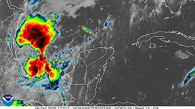
Forecasters have been keeping an eye on a system in the southwestern Gulf of America, currently labeled as Invest 92L, for a few days now, with the latest advisory from the National Hurricane Center noting the system is "showing signs of organization."
The hurricane center said "continued development" of the system is expected, with a tropical depression likely to form over the next day or so as the system drifts eastward. The low pressure area could bring gusty winds and areas of heavy rain to the western portions of the Yucatan Peninsula of Mexico in a couple of days, forecasters said.
"The disturbance is expected to turn to the north or northeast toward the northern Gulf Coast by the end
of the week," the NHC said in an online bulletin at 8 a.m. ET on Tuesday, Oct. 6. "It is still too early to determine specific impacts to the northern Gulf Coast, but interests from the Florida Panhandle to Louisiana should closely monitor the progress of this system."
Forecasters give the system a 90% chance of formation through the next 48 hours. If its winds reach tropical storm strength of 39 mph – along with other factors – it will become a named tropical storm. The next name on the 2026 hurricane list is Isaias, pronounced ees-ah-EE-ahs.
Regardless of tropical development, moisture is expected to spread across parts of the Gulf Coast by the end of this week, producing additional rounds of drenching showers and thunderstorms, according to forecasters at AccuWeather. With the ground already saturated in some areas, additional heavy rain could quickly trigger renewed flash flooding.
"This would add to the flood threat from southern Georgia and the Florida Panhandle westward along Interstate 10 to southeast Louisiana," AccuWeather senior meteorologist Dan Pydynowski said in an online forecast.
Invest 92L spaghetti models
Illustrations include an array of forecast tools and models, and not all are created equal. The hurricane center uses only the top four or five highest-performing models to help make its forecasts.
Gabe Hauari is a national trending news reporter at USA TODAY. You can follow him on X @GabeHauari or email him at Gdhauari@usatoday.com.
This article originally appeared on USA TODAY: Will the system in the Gulf impact the US? See spaghetti models