



While blistering summer heat continues to scorch much of the nation's southern tier this week, that's not the case in the Midwest and Northeast, which are both enjoying a brief fall preview.
Overall, high temperatures are expected to be 5-10 degrees below the historical average from the Great Lakes to the interior Northeast through Aug. 25, AccuWeather predicts.
Highs in the 60s will be common on Aug. 25 in some areas downwind of the Great Lakes.
Conditions in cities such as Detroit, Pittsburgh and Buffalo will be more typical of mid-September rather than late August, according to AccuWeather meteorologist Jack Wojczynski.
Lows in the 40s
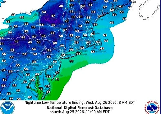
The National Weather Service forecast for the night of Aug. 25 said overnight lows will only be in the 40s across portions of the interior
Northeast. Although on the cool side, no frost is expected yet.
Elsewhere in the Midwest and Northeast, nighttime temperatures are expected to fall into the 50s and 60s.

Some showers possible
With the Great Lakes remaining relatively warm and brisk northwest winds moving in, lake-effect rain showers and storms are expected through Aug. 25 in areas immediately downwind, AccuWeather said.
Warmth returns
According to AccuWeather, the dip in the jet stream that's causing the cool snap is expected to move out of the area beginning Aug. 26, allowing warmer, more humid air to return. That process will occur first over the Midwest and then spread to the Northeast on Aug. 27.
Looking ahead to the weekend and beyond, summer heat will return to the Midwest. A map from the Climate Prediction Center shows above-average temperatures are expected for most of the nation east of the Rockies by early next week. An exception will be the Northeast, where near-normal temperatures are expected.

Southern scorcher
While the Midwest and Northeast see cool temperatures, dangerous, record-breaking heat is continuing across the south-central U.S. into the Southwest this week, NOAA's Weather Prediction Center (WPC) said.
A strong upper-level ridge will remain anchored across the Southwest into south-central U.S. into late week, the WPC said. "This will maintain an abnormal hazardous heat across the region, with daytime highs of 100-110 across the Southern Plains, while portions of the Southwest will reach up to 115."
With overnight temperatures providing limited relief, heat-related illness may increase, especially for those without proper hydration and adequate cooling, the WPC warned.
Doyle Rice is a national correspondent for USA TODAY, with a focus on weather and climate.
This article originally appeared on USA TODAY: False fall? Weather forecast has a surprise