






Much of late July's weather will feature two distinct patterns across the U.S.
While the western and central U.S. bake under a blistering heat wave, the Northeast, mid-Atlantic and Great Lakes states will catch a break from the intense heat; however, the slightly cooler temperatures will be accompanied by some showers and thunderstorms, forecasters said.
What's going on? Thank (or blame) an omega block, a weather pattern that on maps looks like the Greek letter omega (Ω).
"An 'omega block' will develop across the U.S. next week as the Bermuda High builds northward across the Atlantic, and a large ridge will build across the western half of the U.S.," the National Weather Service in Burlington, Vermont, said in an online forecast discussion.
Dangerous heat
Dangerous
heat is set to build this weekend across portions of the western and central U.S. and then expand further across the central U.S. and Gulf Coast next week, forecasters said.
Repeated days of extreme heat are expected due to the combination of hot days and warm overnight lows, the weather service said. NOAA's Weather Prediction Center (WPC) said temperatures could reach 115 degrees in some parts of the Desert Southwest.
"This will cause accumulated heat stress resulting in widespread major, to locally extreme, heat risk," the WPC said. "Anyone without adequate cooling or hydration may experience heat-related health concerns."

El Niño a factor?
While it's summer, and it's supposed to be hot, this heat wave will feature temperatures that are well above the long-term average.
"Two things are driving this heat wave: long-term drought and a fast-emerging El Niño that is bringing persistent high pressure to the Northwest, Great Basin, and northern Rockies,” said Paul Pastelok, AccuWeather lead long-range expert, in an email to USA TODAY.
Next up, the area of high pressure, known as a ridge, will park over the central U.S., NOAA's Weather Prediction Center said in an online forecast.
The ridge will maintain dangerous heat across much of the central-southern U.S. and the Southeast, the WPC said. In the summer, a ridge often brings clear skies and scorching temperatures.
Cooler in the Northeast
While the West bakes, on the other side of the Omega block, the East will see cooler, wetter weather.
"The East Coast of the US will be under an upper-level trough which will lead to chances for showers and thunderstorms most afternoons," the weather service said. During the day, in New England, temperatures will be "slightly below seasonal normal with most areas in the 70s for most of the week."
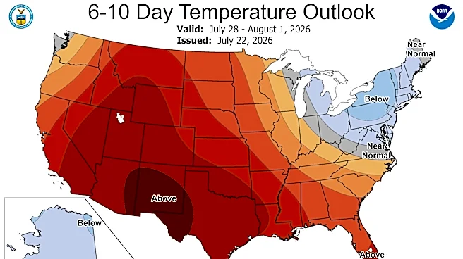
A July 22 map from the Climate Prediction Center shows below-average temperatures in New England extending down into parts of Virginia, Ohio and Michigan through the end of the month.
A round of heavy rain is expected across the Great Lakes and Ohio Valley on Monday, while rainfall and thunderstorms are likely Tuesday across portions of the Mid-Atlantic and Ohio Valley into the Northeast, according to the WPC.
Doyle Rice is a national correspondent for USA TODAY, with a focus on weather and climate.
This article originally appeared on USA TODAY: Forecast says this part of the US is getting a break from summer heat