
Mild temperatures are in the forecast for much of the United States in October, though the occasional cold snap will remind us that winter is coming soon, forecasters say.
"The month of October is expected
to be relatively above average across much of the United States, but there will be pockets of cool air across the Great Lakes and Northeast, with one notable cold shot coming next week that can lead to frost/freeze potential," said AccuWeather meteorologist Peyton Simmers in an email to USA TODAY.
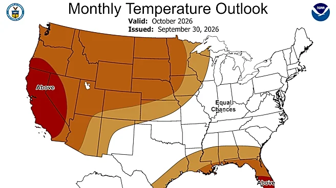
The warmth will be especially pronounced in the western U.S., Anthony Artusa, a meteorologist at NOAA's Climate Prediction Center, said in an online forecast. "The temperature outlook for October favors above-normal monthly average temperatures for nearly all areas west of the Continental Divide," he said.
East of the Divide, he said that unusual warmth is also favored for the northern and central Plains, the upper Mississippi Valley, and in the vicinity of the Gulf Coast.
Specifically, Artusa said "the highest chances of above-normal temperatures are indicated over California and parts of western Nevada and southern Oregon, as well as over most of the Florida Peninsula."

Warm West to raise wildfire risk
Across the western United States, October is going to remain warm and dry with a ridge of high pressure over the region, Simmers told USA TODAY. This can increase the wildfire risk in portions of the West, he added.
Mid-to-late month looks fairly quiet across much of the country, he said. In addition, the tropical Atlantic is expected to remain quiet through October.
Hello El Niño — Soggy across the southern tier
Despite this being early in the fall season, the southern storm track commonly observed with strong El Niños is already beginning to take shape, Artusa said.
"The updated precipitation outlook for October favors above-normal precipitation for most of the southern tier of the contiguous U.S., from southern Arizona eastward across the southern Plains, lower Mississippi and Tennessee Valleys, and the Southeast," he said.
This wet pattern is heavily front-loaded (within the first 7-10 days of October) and is associated with several high-pressure systems and their accompanying surges of cooler Canadian air moving southward to near the Gulf Coast. "The respective cold fronts representing the leading edges of these cooler surges are forecast to stall across the deep South, accompanied by easterly surface flow and increasingly moist conditions," Artusa said.
According to Simmers, some other effects of El Niño are also being seen, such as the quiet tropical Atlantic and the ridge of high pressure in the West. "However, El Niño effects tend to get stronger as fall progresses towards winter."

Dry in the western U.S.
Below-normal precipitation is favored from the upper Mississippi Valley/western Great Lakes region west-southwestward across the northern and central Rockies, and the northern and central Great Basin to nearly all of the West Coast, Artusa said.
In the Pacific Northwest, conditions look abnormally dry at least through the first half of October, according to Artusa.
One wild card: "This fall, given the current strength of El Niño and the very active (Pacific) tropical cyclone season thus far, the possibility of a tropical system affecting the Southwest extends into the autumn season even later than usual."

Doyle Rice is a national correspondent for USA TODAY, with a focus on weather and climate.
This article originally appeared on USA TODAY: October weather forecast calls for a 'notable cold shot' and frost