
By Pesha Magid, Nidal al-Mughrabi and Alexander Cornwell
JERUSALEM, April 29 (Reuters) - New maps of Gaza quietly issued by Israel a little more than a month ago have put thousands of displaced Palestinians
inside an expanded restricted area, within boundaries the military says it can continue to change.
The restricted area, marked on the maps with an orange line, makes up an estimated 11% of Gaza's territory beyond the "Yellow Line" demarcating the part of Gaza occupied by Israeli troops since an October ceasefire. The areas cordon off nearly two-thirds of Gaza's territory in total.
Israel's military sent the maps to aid groups in Gaza in mid-March, two aid sources said, but has not released them publicly.
Israel says the area between the orange line and the yellow truce line to which its troops withdrew under an October deal is a restricted zone to enable aid delivery, and that aid groups must coordinate their movements with the military. It says civilians are not affected.
The expanded zone has stirred fears from displaced Palestinians living there that they could be deemed targets by Israel, and shot. It has also stoked concerns that Israel may plan to hold the area permanently.
Israeli officials describe the territory they've seized in Gaza, Syria and Lebanon as "buffer zones" that can stave off potential militant attacks following the October 7, 2023 Hamas-led, assault that set off the Gaza war.
"In Gaza, more than half of the Strip's territory" is under Israeli control, Netanyahu said in a March 31 video statement. "We are the ones who attack and initiate, and we are the ones who surprise our enemies."
'PEOPLE DON'T KNOW WHAT IS WHAT'
Israel's expanding control beyond the line agreed in the U.S.-brokered October ceasefire casts further doubt on President Donald Trump's Gaza plan, held up for months due to the Iran war and disagreements over disarming Hamas militants.
It also widens the zone in which Israel's military says it could operate and carry out deadly attacks against Palestinians, without marking it on the ground. The October ceasefire line was marked with concrete blocks painted yellow. Israel has previously moved those blocks deeper into Hamas-controlled territory, Reuters has reported.
Issuing its first public comments on the expanded zone, COGAT, the Israeli military agency that controls access to Gaza, said it had defined areas adjacent to the Yellow Line in which international organizations including humanitarian groups were required to coordinate their movements with the military.
"The boundaries of these areas (the Orange Line), in which coordination is required, are determined and updated in accordance with the operational situational assessment, with the aim of enabling humanitarian activity while safeguarding personnel in a complex operational environment," COGAT said.
COGAT declined to comment when asked how frequently it updates and distributes maps to aid groups showing the location of the orange line, and whether it has communicated its location to Palestinian civilians.
At least three Palestinians working with foreign aid groups -- two with UNICEF, and one with the World Health Organization -- have been killed by Israeli attacks in the area between the two lines since mid-March.
In both cases, Israel's military said it had identified threats near the Yellow Line and had opened fire as a result. UNICEF and the WHO did not immediately respond to a request for comment on whether they coordinated their workers' movements with Israel.
Rani Ashour, who lives in a camp for displaced people near Gaza City that sits between the two lines, said residents lacked water and other aid because humanitarian groups feared sending staff there.
"People don't know what is what, (the orange) line is here today, you sleep, and you wake up, and you find it has passed you."
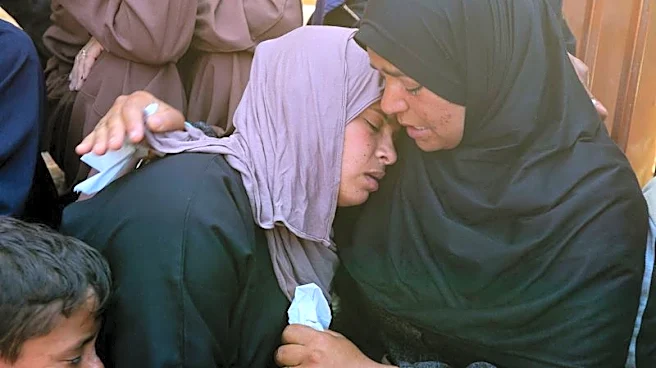
Since the ceasefire, local medics say Israeli fire has killed more than 800 Palestinians in Gaza, many of them in the area near the Yellow Line, which is dotted with displaced persons camps and people living in bombed-out buildings. Four Israeli soldiers have been killed during the same period.
NEW MAP APPEARS TO SHOW SHIFTING LINES
The two aid sources, both working in Gaza, said the military originally sent aid groups a map showing an expanded zone beyond the Yellow Line after the October ceasefire. That map was published by groups including UNICEF, but never by the military.
The military sent the groups an updated version of the map in mid-March, said the sources, who shared images of the map with Reuters but declined for them to be published directly. The new map shows the Yellow Line and marks the expanded zone with an orange line.
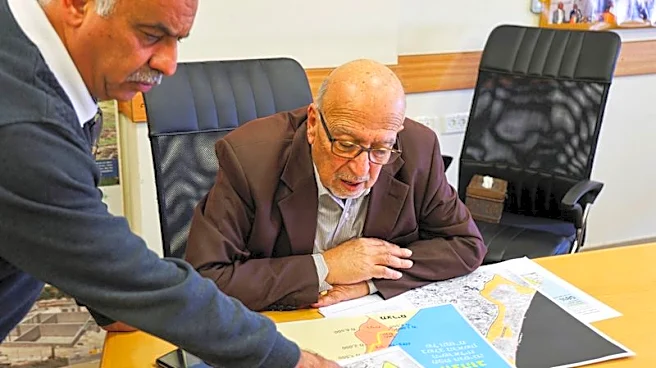
Reuters shared the images with Palestinian researchers who superimposed the two lines onto a map. The two aid sources said that the Yellow Line had moved forward to encompass the original expanded zone, with the orange line marking the boundaries of an even bigger restricted area.
The military declined to comment when asked whether the Yellow Line had been moved forward, but said that the "area adjacent to the Yellow Line is a sensitive and dangerous operational environment", and that "(signs) are posted in the area indicating that it is forbidden to approach".
That in effect leaves Israel in control of at least 64% of Gaza, said Jad Isaac, director general of the Applied Research Institute-Jerusalem, an independent Palestinian think tank in the occupied West Bank, with the nearly 2 million population almost entirely confined to a sliver of Hamas-controlled territory along the coast.
"They want to put as many Palestinians as possible in the smallest area in order to drive them out because of the absence of any viability or any sustainability in what's left of Gaza," Isaac said.
Israeli officials including Bezalel Smotrich, a minister in Netanyahu's government, have called for Palestinians to leave Gaza, reinforcing Arab fears that Israel wants to drive Palestinians from land where they seek a future state.
Behind its Yellow Line, Israel has forced civilians out and bulldozed most remaining buildings, while the U.S. and UAE have drafted development plans for the territory.
Amjad al-Shawa, the head of the Palestinian NGOs Network in Gaza, said the additional line of control had caused confusion and concern.
"Residents do not know where the lines begin or end. One day, the boundary is in one location, and the next day it shifts without warning," Shawa said.
(Reporting by Pesha Magid and Alexander Cornwell in Jerusalem and Nidal al-Mughrabi in Cairo; Writing by Rami Ayyub; Editing by Aidan Lewis)