






Fall is underway in Western North Carolina, and temperatures low enough to produce areas of frost are forecast this weekend throughout the region.
The National Oceanic and Atmospheric Administration explains that, while temperatures of 32 degrees and below are considered freezing,freezing temperatures are not necessarily required for frost to form
. Instead, certain combinations of weather conditions combined with low temperatures lead to frosty conditions.Clear skies leading to radiational cooling, calm to light winds preventing stirring of the atmosphere and cool temperatures are also conducive to creating frosty conditions. Local topography also has a large role in determining if and where frost develops, such as cold air tending to settle
in valleys.
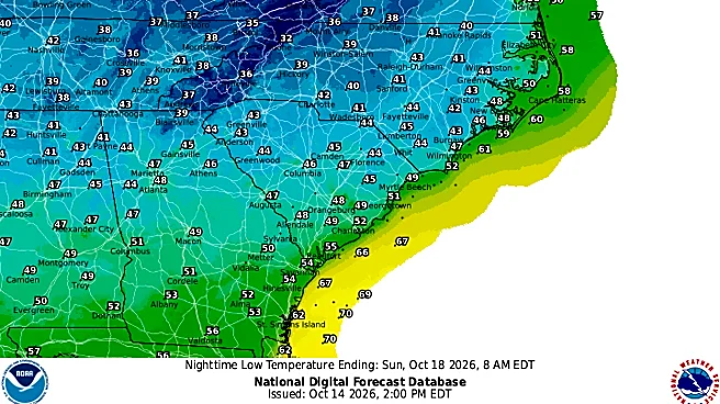
As of Wednesday, Oct. 14, the National Weather Service predicts low nighttime temperatures in the mid-30s in Asheville and throughout Western North Carolina this weekend. And it could be cool enough for the first frost of the year.
What temperature does frost form at?
NOAA explains that freezing temperatures of 32 degrees and below are not necessary to create frost. One study cited by the organization found that temperatures from 38-42 degrees can lead to patchy frost, 33-37 degrees can lead to areas of frost and 32 and below to widespread frost and freezing.
What is the average first frost date in Asheville, NC?
According to a study from N.C. State University, average first freeze dates in Buncombe County, with locations in Asheville and Buncombe County measured, range from Oct. 17-25.
Will there be frost this weekend in Western NC?
While no freezing temperatures are forecast in Asheville over the weekend as of Wednesday, Oct. 14, temperatures are currently forecast to reach the mid-30s at night in the North Carolina mountains, meaning that some areas of frost could form.

Asheville, Western NC weekend temperatures, weather
Check out the weather service's weekend predictions for Asheville:
- Friday, Oct. 16 - Sunny, with a high near 82. Calm wind becoming west 5 to 8 mph in the afternoon. Overnight: A 30% chance of showers, mainly between 9 p.m. and 2 a.m. Mostly cloudy, with a low around 44. Breezy, with a northwest wind 17 to 20 mph, with gusts as high as 37 mph.
- Saturday, Oct. 17: Mostly sunny, with a high near 57. Overnight: Patchy frost after 3 a.m. Otherwise, mostly clear, with a low around 34.
- Sunday, Oct. 18: Areas of frost before 9 a.m. Otherwise, sunny, with a high near 60. Overnight: Mostly clear, with a low around 35.
Hendersonville, NC weekend temperatures, weather
As of Wednesday, Oct. 14, the weather service weekend predictions for Hendersonville include:
- Friday, Oct. 16 - Sunny, with a high near 80 degrees. Light west wind increasing to 9-14 mph in the afternoon. Winds could gust as high as 22 mph. Overnight: Partly cloudy, with a low around 45 degree. Breezy, with a north northwest wind 14 to 21 mph, with gusts as high as 39 mph.
- Saturday, Oct. 17 - Sunny, with a high near 57 degrees. Overnight: Patchy frost after 4 a.m. Otherwise, mostly clear, with a low around 36 degrees.
- Sunday, Oct. 18 - Areas of frost before 8 a.m. Otherwise, sunny, with a high near 56. Overnight: Mostly clear, with a low around 36 degrees.
Iris Seaton is the trending news reporter for the Asheville Citizen Times, part of the USA TODAY Network. Reach her at iseaton@citizentimes.com.
This article originally appeared on Asheville Citizen Times: Cold snap forecast for Western North Carolina. Could there be frost?