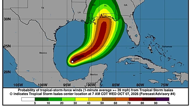








The National Hurricane Center announced today, Wednesday, Oct. 7, that Tropical Storm Isaias has formed off the Gulf Coast.
The tropical storm, which is the ninth named tropical storm of the Atlantic hurricane season, is the first of the season expected to strengthen into a hurricane. The storm's path is expected to meet the northern Gulf Coast on Friday, Oct. 9, with winds of over 100 mph expected.
Forecasters believe that the storm will peak before making landfall, but it could still be a "significant" hurricane when it reaches the coast, with strong winds and flooding rain, according to USA TODAY. As of 10 a.m. on Oct. 7, the storm had maximum sustained winds of 45 mph and was moving east-northeast at 8 mph.
Here's what to know about Isaias's
possible impact in North Carolina from the National Oceanic and Atmospheric Administration.
Has a tropical storm formed? What to know about Tropical Storm Isaias
According to an advisory issued by the NOAA at 10 a.m. on Oct. 7, Tropical Storm Isaias is expected to strengthen into a strong hurricane before approaching the northern Gulf Coast on Oct. 9. The advisory warned that there is an "increasing risk of life-threatening storm surge along portions of the northern Gulf Coast," with a Storm Surge Watch issued from the mouth of the Mississippi River to Yankeetown, Florida.
Will Tropical Storm Isaias affect North Carolina? Where will Tropical Storm Isaias hit?
According to NOAA, Isaias is also expected to bring areas of heavy rainfall to the central U.S. Gulf Coast and much of the Southeast on Friday and into the weekend, Oct. 9-11, with flash and urban flooding along with isolated river flooding possible.
Main states in the probable path of the storm's center include: Florida, Alabama, Mississippi, Tennessee, Kentucky, Indiana, Illinois, Missouri, Arkansas and Georgia. However, NOAA alert noted that hazardous conditions can occur outside of the cone.

Will Tropical Storm Isaias cause flooding in North Carolina?
In North Carolina, flash flood risks caused by Tropical Storm Isaias are between marginal and slight, or 5-15%. Greatest risks are in parts of Western N.C. and the coast near Wilmington.

Asheville, NC weather this week
As of late morning on Wednesday, Oct. 7, NOAA's forecast for the Asheville area through Sunday, Oct. 11, includes:
Wednesday, Oct. 7 - Sunny, with a high near 80 degrees. Calm wind. Overnight, patchy fog after 4 a.m. Otherwise, mostly clear, with a low around 50 degrees. Calm wind.
Thursday, Oct. 8 - Patchy fog before 10 a.m. Otherwise, sunny, with a high near 82 degrees. Calm wind becoming north northwest 5-7 mph in the afternoon. Overnight, partly cloudy, with a low around 51 degrees. Light northwest wind.
Friday, Oct. 9 - Mostly sunny, with a high near 79 degrees. Calm wind becoming southeast around 6 mph in the afternoon. Overnight, mostly cloudy, with a low around 54 degrees.
Saturday, Oct. 10 - A 40% chance of showers after 2 p.m. Mostly cloudy, with a high near 71 degrees. Overnight, a chance of showers and thunderstorms before 8 p.m., then showers likely and possibly a thunderstorm between 8 p.m.-2 a.m., then showers after 2 a.m. Low around 55 degrees. Chance of precipitation is 90%.
Sunday, Oct. 11 - Showers, with thunderstorms also possible after 8 a.m. High near 71 degrees. Chance of precipitation is 90%. Overnight, showers likely, mainly before 8 p.m. Mostly cloudy, with a low around 57 degrees. Chance of precipitation is 60%.
Hendersonville, NC weather this week
In the Hendersonville area, NOAA predicts the following through Sunday:
Wednesday, Oct. 7 - Sunny, with a high near 76 degrees. Calm wind. Overnight, patchy fog after 4 a.m. Otherwise, mostly clear, with a low around 51 degrees. Calm wind.
Thursday, Oct. 8 - Patchy fog before 10 a.m. Otherwise, sunny, with a high near 80 degrees. North northwest wind around 6 mph. Overnight, increasing clouds, with a low around 53 degrees. Light northwest wind.
Friday, Oct. 9 - Mostly sunny, with a high near 76 degrees. Calm wind becoming east around 6 mph in the afternoon. Overnight, mostly cloudy, with a low around 54 degrees.
Saturday, Oct. 10 - A 40% chance of showers after 10 a.m. Mostly cloudy, with a high near 68 degrees. Overnight, showers and possibly a thunderstorm. Low around 55 degrees. Chance of precipitation is 90%.
Sunday, Oct. 11 - Showers and possibly a thunderstorm. High near 68 degrees. Chance of precipitation is 90%. Overnight, a 50% chance of showers before 2 a.m. Mostly cloudy, with a low around 57 degrees.
Iris Seaton is the trending news reporter for the Asheville Citizen Times, part of the USA TODAY Network. Reach her at iseaton@citizentimes.com.
This article originally appeared on Asheville Citizen Times: Tropical Storm Isaias expected to become a hurricane. See NC impact