




Access to water, and, more importantly, clean drinking water, remains a challenge for many people on the Navajo Nation, so Northern Arizona University chemistry professor Jani Ingram and a team of researchers took on the challenge. They created a map identifying wells with water that is considered safe to drink and those that may be best avoided.
Ingram, a citizen of the Navajo Nation, has been at NAU since 2002. Upon arriving she almost immediately started working on some of the contaminant issues, particularly water contamination on the Navajo Nation related to legacy uranium mining.
She said her work was motivated by uranium mining and community members who "requested for this type of work to be done."
After receiving a grant that focused on
cancer within the Native American community she, she decided to put it to work. Due to the region’s extensive history of uranium mining, and because private well water isn’t regulated by the Safe Drinking Water Act, much of that water is contaminated and unsafe to drink.
"There wasn't a lot of information provided to Navajo folks when they were actually doing the (uranium) mining, then the mining companies left... (they) left a mess out there," Ingram told The Arizona Republic. "Folks then started to see health effects for their loved ones, their friends, their neighbors. It seems as though legacy mining had something to do with it, that's why a lot of communities are really seeking assistance with scientists."

The long road to creating a water map
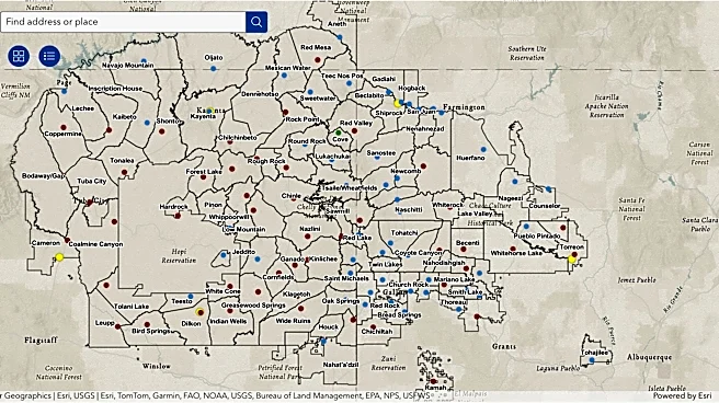
The interactive map shows locations across the Navajo Nation where residents can access water.
Blue and red dots show transitional and existing permanent water points offering free water through the Navajo Water Access Mission. Yellow dots show NTUA-operated water points where water may require payment.
Transitional and permanent water points also provide water storage containers and disinfection tablets, as needed, to residents of homes without piped water.
Ingram said they began collecting water data in 2003 and, by 2017–2018, she and her students started to collaborate with the University of New Mexico.
"We decided it would be really useful to the Navajo Nation to combine as many data sets as we could so that this map could be built," said Ingram. "There were people who do the mapping work at University New Mexico, but they, of course, need the information. Then COVID hit in 2020, and the the mapping became even more important because now people had to go through lockdowns on the weekends and curfews in the evening."
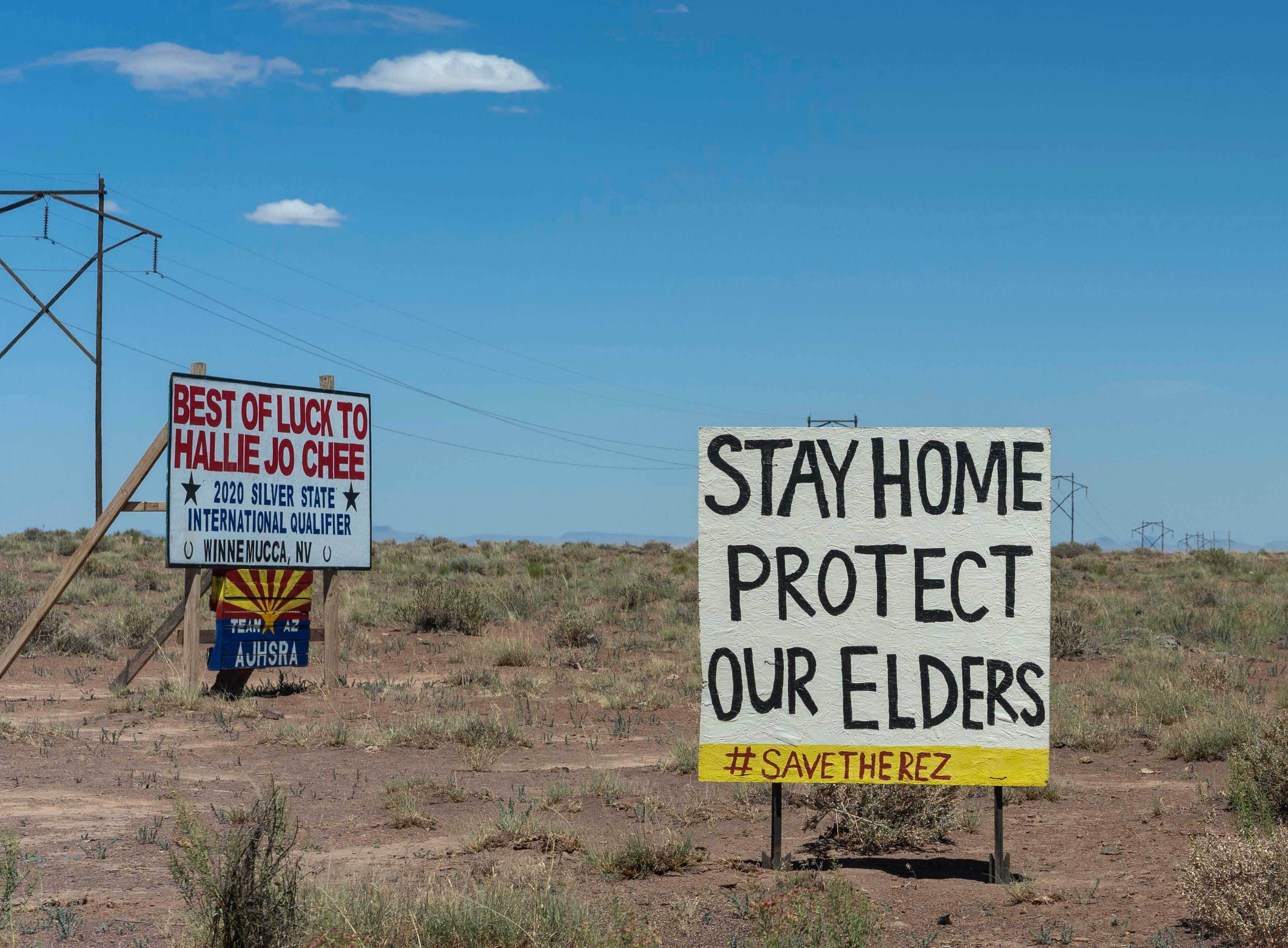
When COVID-19 hit the Navajo Nation in March 2020, tribal officials imposed evening curfews and 57-hour weekend lockdowns to try to contain the spread. It became clear the Navajo Nation had been hit hard by COVID due to the lack of running water.
In 2020, the Indian Health Services identified approximately 9,650 homes on the Navajo Nation without piped water in their homes. There are an estimated 37,000 people without water, or about 20% of the Navajo Nation population.
NTUA reports that 30% of Navajo Nation homes lack access to piped water service. Occupants of these homes likely rely on hauled water as their primary source for water.
Ingram said historical information from the U.S. Army Corps of Engineers helped, but it was old information. The collaboration and support from local communities had the greatest impact on the mapping development.
"We really needed the community to help us to say 'These are the wells that we use,'" said Ingram. "'These are the wells that people no longer draw water. This where the wells are.' So honestly, we we couldn't do this work if we didn't collaborate with the community members."

Water is contaminated after years of mining
In 1948, the U.S. Atomic Energy Commission guaranteed prices for and purchased all domestically mined uranium, sparking a mining boom across the Colorado Plateau in Arizona, New Mexico, Utah and Colorado.
The federal government remained the sole U.S. uranium purchaser until 1971, while private companies operated the mines. The Navajo Nation continues to face the legacy of over 40 years of uranium mining after companies abandoned more than 500 mines, with some estimates suggesting the true number may exceed 1,000.
Research demonstrates that mining activities released elemental contamination into ground and surface water systems, creating health risks. Some work was focused on analyzing water sources for per- and polyfluoroalkyl substances, or PFAS. These studies emphasized sampling unregulated water systems and characterizing water quality in sources across the Navajo Nation. Because all samples were collected from water sites labeled as “unregulated,” there is no obligation to monitor these sites or warn communities of any contamination.
During a recent meeting with the American Chemical Society, Ingram presented her research, explaining that the abandonment of uranium mines has allowed uranium and other heavy metals to seep into nearby water sources.
While cleanup efforts are underway at some abandoned mines, many continue to pose a potential risk to wells that provide drinking water for people and livestock. Uranium exposure has been associated with serious health concerns, including kidney disease, lung cancer and reproductive problems.
"It became clear that no one was monitoring these wells,” said Ingram. “Everyone on the reservation in that situation is on their own to find a water source for their households.”
Because many of the wells were on rural lands that are difficult to reach, Ingram relied on community members and students to accompany her and locate wells from which to retrieve water samples.
She and her collaborators found that uranium levels in some of the wells were above 30 parts per billion, the upper limit for safe drinking water set by the U.S. Environmental Protection Agency. The research team also found elevated levels of arsenic and manganese in some samples, other harmful substances that can cause cancer and neurological disorders.
“Having this data is really good for the community,” Ingram says. “If they request that a new well be dug, it tends to be that the deeper the well, the cleaner it is. If they have a regulated well, they can request a filter system for it. Our data gives them another tool to help make those arguments.”
Ingram said they're looking at gardens and almost farm-like growing areas in communities where there has been mining. The group is studying how plants take up metals to help determine whether the produce is safe for people to eat.
More often than not, she said, the metals tend to accumulate in the root.
"For example, the kernels of a corn plant, there's quite a bit less to trace levels at that point, but it's good information for the community," said Ingram. "We're continuing to work on soil and water sort of requests from different communities that we haven't worked as much with."
Sharing this information with communities and tribal leadership is important to Ingram because it can help community members make informed decisions about where to grow crops, where to obtain safe water, and whether additional wells should be placed in specific areas.
Arlyssa D. Becenti covers Indigenous affairs for The Arizona Republic and azcentral.com. Send ideas and tips to arlyssa.becenti@arizonarepublic.com. Follow her on Bluesky at @abecenti.bsky.social.
This article originally appeared on Arizona Republic: Diné NAU professor maps safe drinking water on the Navajo Nation