



Rain chances for metro Phoenix are coming soon, but give it a little time. While we finish out the first full week of August, we’re still under a high-pressure dome trapping heat and humidity up to the weekend.
Temperatures have been right around average thanks to recent cloud cover, which will continue much of Thursday, Aug. 6, but high dew points in the 60s will keep the “feel like” temperatures between 110-120 degrees. This cloud cover also will dissipate soon while the heat remains.
Storm chances will stay isolated to higher elevations to our east and southeast. While storms were quite active in southeast and far southern Arizona on Wednesday night, activity was rather lackluster around the Valley due to the capping of instability.
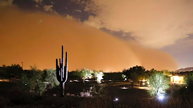
We did get
a dust storm overnight through Pinal and Maricopa counties, leading to unhealthy air quality Thursday morning and a high pollution alert from the Arizona Department of Environmental Quality for the day. This dust storm was not as powerful as the one from Monday night, Aug. 3, and the dust is expected to slowly mellow throughout the day.
Similar conditions will be possible on Friday, Aug. 7, as all of our gusty wind, dust or low rain chances are dependent upon outflow boundaries moving our way.
On Thursday and Friday, Aug. 6 and 7, the high-pressure ridge that’s been towering over us will begin to strengthen and shift to northern Arizona. This shift allows in some slightly drier air that’ll decrease rain chances across the board. Eastern high terrains will only get up to a 30% chance and lower deserts closer to 10%. While dew points fall a bit, temperatures will be peaking on Friday and Saturday between 110-115 degrees, and it’ll still feel muggy with heat indices up to 120.
For this reason, extreme heat warnings in central, southwestern and western Arizona were extended to Sunday night, Aug. 9.
But beginning on Sunday, the high-pressure ridge is expected to weaken once again and make a move toward the Four Corners. This will allow for better monsoon activity, displayed by increasing moisture and better upper-level support for storm activity.
You’ll see forecasts with rain chances as early as Sunday, but it may take a second for drier air to be filtered out. Better days come starting Monday, Aug. 10, and the following week. The Climate Prediction Center has most of Arizona marked for heavy precipitation Thursday through Saturday, Aug. 13-15.
This pattern shift will also bring “cooler,” more average temperatures through the week.
We want to see your weather photos: Send to weatherpix@arizonarepublic.com, or on Instagram @azcentral or TikTok @azcentral. Attach your photos and tell us all about what's pictured. They may appear in an online story or in the newspaper.
Meteorologist Tevian Whitehurst covers extreme weather and climate for The Republic and azcentral.com. Follow him at @TevianWX on Instagram and Facebook (Meteorologist Tevian Whitehurst).
This article originally appeared on Arizona Republic: Hot, humid, hazy weather hangs over Phoenix. When will rain return?