
After a delayed start to storms that didn’t arrive until late Wednesday morning, Sept. 16, metro Phoenix got a real dousing, and scattered chances lasted through the night. That all will come to a close
during the latter half of the week.
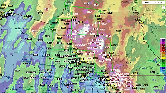
The far East Valley, north Phoenix and north Scottsdale saw rain totals ranging from 1.50 to 4 inches, and flood impacts were felt around the region. Local roads and highway routes were made impassable, and a series of water rescues were made by vehicles trying to push through the floodwaters.
Sky Harbor International Airport briefly grounded all flights during the early afternoon. At the peak of storms, thousands of SRP and APS customers lost power.
Some of the highest rainfall totals include:
- Thunder Mountain (northeast Mesa): 3.90 inches
- Skyline Park (east Mesa): 3.27 inches
- Cave Creek: 3.74 inches
- Ranch Gate Road (north Scottsdale): 2.91 inches
- Pima Road/Union Hills Drive (north Scottsdale): 2.83 inches

Moving south and westward in the Valley, rain totals get gradually lighter until nearing southern Maricopa County. Parts of north Phoenix within the Loop 101 loop saw totals ranging from 0.15 to 0.75 of an inch and parts of the West Valley generally saw even less.
Looking forward, the surge of moisture brought to us by a tropical disturbance in the Gulf of California will get redirected. The perfect balance of the eastern high pressure and western low pressure will be disrupted as the low keeps pushing our way and shifts winds to come out of the west, slowly drying out the whole state of Arizona heading into the weekend.
Clouds will remain for much of Thursday, Sept. 17, keeping temperatures under 100 degrees for many, but it will still be quite humid, with dew points in the 60s.
Those numbers drop significantly by the weekend, with some dew points in Arizona falling down to the 20s and 30s between Saturday and Sunday, Sept. 19 and 20, as temperatures rise back to seasonal normals around 100 to 102 degrees.
Meteorologist Tevian Whitehurst covers extreme weather and climate for The Arizona Republic and azcentral.com. Follow him at @TevianWX on Instagram and Facebook (Meteorologist Tevian Whitehurst).
We want to see your weather photos: Send to weatherpix@arizonarepublic.com, or on Instagram @azcentral or TikTok @azcentral. Attach your photos and tell us all about what's pictured. They may appear in an online story or in the newspaper.
This article originally appeared on Arizona Republic: After wild run of heavy rain and flash floods, will Phoenix area dry out?