





While south-central and southwestern Arizona are baking in triple-digit heat, the next chance for rainfall and cooler weather is cooking in the eastern Pacific Ocean.
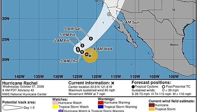
Hurricane Rachel, the latest in a series of Pacific storms in recent weeks, spent most of its life in warm waters a couple of hundred miles off the Mexican coastline. But since early this week, it’s been moving west-northwest out to sea, away from the continent and the warm, tropical waters it was born in. This has been due to the high pressure sitting over the Southwest directing it that way.
But sometime on Friday, Oct. 9, Rachel will have a new boss: low pressure troughing in the Pacific. Rachel is expected to be a weakening tropical storm by that point, making it easy for a smaller
shortwave system to snatch it up and create a sharp turn in the track from northwest to northeast. This reorients the storm back toward the Southwest, with its mid-level moisture slated to arrive in Arizona as soon as Saturday, Oct. 10.
Landfall is expected on Baja California as a tropical storm early Sunday, Oct. 11, then Rachel will likely be down to a tropical depression by the time it reaches the Southwest region.
Late or overnight Saturday is the absolute earliest the Valley could see any activity, but the majority of impacts are expected on Sunday and Monday, Oct. 11 and 12, when lower-level moisture can flow into the state as well. The smaller shortwave that snatched up Rachel will also get grabbed by an even broader trough that will be sinking into California and the West Coast overall. As it rolls inland, it provides better upper-level support for storm activity over those two days.
The strongest impacts are expected in north-central and western Arizona, southern California, southern Nevada and southwestern Utah. Showers and storms are expected in the rest of State 48, but nothing is concrete given how far away the event is.
The Valley is primarily expecting moderate rainfall and windy conditions. While the heaviest rainfall is expected in high elevations just north of the city, metro Phoenix could see anywhere from 0.5 to 2 inches of rain, with those to the north in higher favor. With the multi-day period, the risk of heavy rainfall leading to flash flooding is also still uncertain, plus some lingering activity could last into Tuesday, Oct. 13, so stay up-to-date with the forecast.
Gusty winds are another risk to watch: Sunday currently shows the strongest gusts up to 40 mph.
Along with this, temperatures will be on a major decline from the weekend onward. Saturday is expected to be in the mid-90s, while the appearance of stormy activity may keep temperatures in the 80s on Sunday and Monday, possibly even the lower 80s by Tuesday.
Meteorologist Tevian Whitehurst covers extreme weather and climate for The Arizona Republic and azcentral.com. Follow him at @TevianWX on Instagram and Facebook (Meteorologist Tevian Whitehurst).
We want to see your weather photos: Send to weatherpix@arizonarepublic.com, or on Instagram @azcentral or TikTok @azcentral. Attach your photos and tell us all about what's pictured. They may appear in an online story or in the newspaper.
This article originally appeared on Arizona Republic: Odds increase that Arizona could see rain from Hurricane Rachel