





Chances are growing that 2026 will be a year without a hurricane, but there are no promises yet with forecasts whispering of a potentialtropical contrarian bubbling in the southwestern Gulf.
Colorado State University hurricane researcher Phil Klotzbach estimated that there is a about a 50% chance of a hurricane-free season after September came and went with four named storms, but no hurricanes.
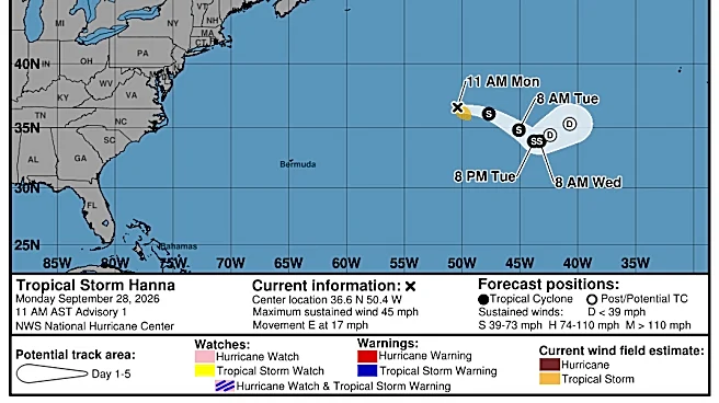
And in its two-week tropical forecast issued Sept. 30, CSU is calling for a 78% chance ofbelow normal Atlantic tropical activity through Oct. 13 with Hanna fizzling and nothing on the National Hurricane Center’s radar for the near future. There is just a 2% chance ofabove normalactivity.
“All it takes is for something weird to happen late in the season,”
Klotzbach cautioned. “Are we going to get a major hurricane coming off Africa, no, but we could get something.”
Hurricane season runs June 1 through Nov. 30.
Of September’s named storms — Edouard, Fay, Gonzalo and Hanna — only Fay came close to hurricane strength topping out at 70 mph, 4 mph short of the earning the title. Edouard's sustained winds made it to 60 mph.
Will El Niño completely close the door on hurricane season?
Meteorologists said they’re not overly surprised about the quiet season. Early forecasts called for below average tropical activity and the deepening El Niño helped verify those predictions.
El Niño, a periodic climate pattern that crushes tropical cyclones with a firehose of wind shear through the Caribbean and tropical Atlantic, has a high chance of exceeding the strength of previous El Niño events dating back to 1950.
It could grow so powerful, it exceeds the meteorological labels of “strong” and “very strong” awarded previous top performers.
“I think there is a good chance we get through without a hurricane but I’m not writing the season off yet,” said Bryan Norcross, FOX Weather hurricane expert. “I’m not ready to say that EL Niño is going to cancel hurricane season.”
That’s partly because El Niño’s storm-shredding winds are mostly felt in the Caribbean and tropical Atlantic. But in October, hurricanes can brew in the southwestern Gulf and Bay of Campeche.
Florida State climatologist Emily Powell said sea surface temperatures in the Gulf are record warm for this time of year, offering plenty of fuel for anything that may spin up there.
In the fall, tropical cyclones can form along cold fronts making early trips into more southerly latitudes. They can also grow out of the Central American Gyre, an area of low pressure that bookends hurricane season but is a more prolific storm producer in the fall when waters are warmer.
“In a typical hurricane season, our most active month is September, but October is the second most active month,” Powell said.
Heavy hitters such as hurricanes Wilma, Michael and Milton have all targeted Florida in October. Wilma made landfall on Oct. 24, a late-season Category 3 at impact that raked through the state from Cape Romano on the southwest coast to Jupiter on the east coast.
Still, seasonal hurricane benchmarks have made little difference this year.
The average date for the first Atlantic hurricane is Aug. 11. The average date for the season's first major hurricane of Category 3 or higher is Sept. 1.
The latest date that a hurricane has formed in the satellite era previous to this year was Sept. 11 when Hurricane Gustave was born in 2002 and Hurricane Humberto formed in 2013.
“The fact that this hurricane season is being extreme doesn’t surprise me in a macro sense, but the fact that we don’t have any hurricanes is very, very unusual,” Norcross said.
On record, only the years 1907 and 1914 went without a hurricane.
Colorado State University reduced its number of named storms expected to form between June 1 and Nov. 30 to nine from an original tally of 13 that it predicted in April.

With Hanna being the eighth named storm, the season is nearing CSU’s named storm prediction but is far below an average season’s 14 named storms.
The amount of accumulated cyclone energy (ACE), which measures storm strength and longevity is also far below normal. This season’s ACE is 10.8 through Sept. 30. An average season has 94 at this point in the year.
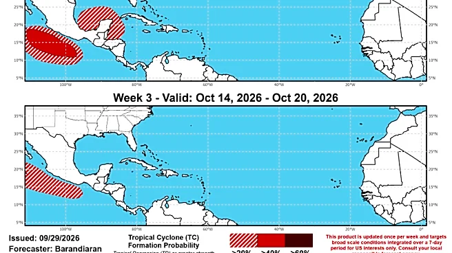
Climate Prediction Center forecasters are watching an area in the southwestern Gulf and Bay of Campeche for potential development the week of Oct. 7-13.
Michael Lowry, a WPLG Channel 10 meteorologist, said forecast models are hinting at something forming in that area from a cold front predicted to stall over Florida and the Gulf.
“For now, it’s nothing to worry about, but something we’ll follow,” he said in his forecast.
Kimberly Miller is a journalist for the USA TODAY NETWORK FLORIDA. She covers weather, the environment and critters as the Embracing Florida reporter. If you have news tips, please send them to kmiller@pbpost.com. You can get all of Florida’s best content directly in your inbox each weekday by signing up for the free newsletter, Florida TODAY, at palmbeachpost.com/newsletters.
This article originally appeared on Palm Beach Post: A hurricane-free 2026 is within reach, but we're not in the clear yet
Our editors independently choose our recommendations. Some content is produced with paid support from a third party, however our editorial decisions remain independent. If you buy through our links, the USA TODAY Network may earn a commission. Prices and availability may change.