

The National Oceanic and Atmospheric Administration slightly reduced its number of expected tropical cyclones for this hurricane season as slower activity is expected even as peak season nears.
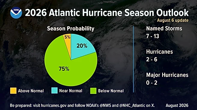
An updated forecast released Aug. 6 continues to call for a below normal season with seven to 13 named storms, including two to six hurricanes. Of the hurricanes, up to two are expected to grow to Category 3 or higher.
NOAA's Climate Prediction Center had originallyforecast in May up to 14 named storms and three to six hurricanes. It was the first time since 2015 that the NOAA forecast called for a less active season.
The announcement follows Colorado State University's updated forecast released Aug. 5, which maintained a total of nine named storms for the
season. With tropical storms Arthur and Bertha come and gone, that leaves seven more storms per CSU's prediction through season's end on Nov. 30.
A normal hurricane season based on an average from the years 1991-2020 has 14 named storms, seven hurricanes and three major hurricanes.
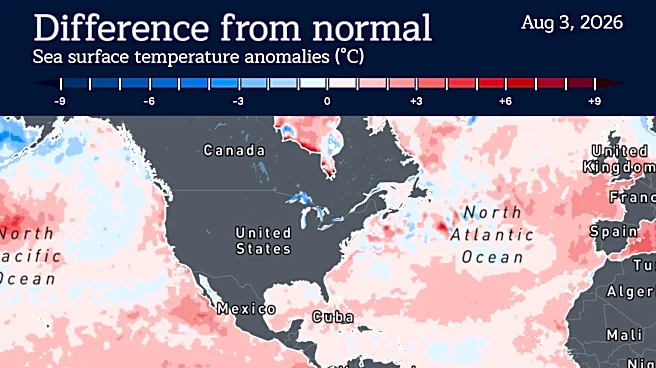
NOAA's forecasters cited similar challenges for storms to spin up this year as to what CSU mentioned; cranking wind shear through the Caribbean induced by a strong El Niño and only slightly warmer than normal sea surface temperatures in the main development region between Africa and the Caribbean.
"When El Niño emerges, it usually becomes the dominant factor in total hurricane season activity, and this El Niño continues to get stronger every month,” said Matt Rosencrans, lead hurricane season forecaster with NOAA’s National Weather Service, in a statement. "Compared to a mature El Niño, other mechanisms play a smaller role in determining the number and intensity of tropical storms in the Atlantic basin.”
Unlike previous years where a waffling atmosphere has muddled seasonal forecasts, experts said this year sits on more solid footing with El Niño already in place and strengthening.
As of a July 9 forecast for the El Niño Southern Oscillation, which includes El Niño and La Niña, there is very high confidence that the periodic climate pattern will persist into early 2027. There is an 81% chance that a very strong El Niño will develop during the October to December time period that would "rank among the largest El Niño events in the historical record dating back to 1950."
"A curtain of wind shear is draped across the tropical Atlantic courtesy of the fast-developing Super El Niño and has assembled a road block with little detour for wannabe storms," said WPLG Channel 10 in Miami hurricane expert Michael Lowry in his Aug. 6 Eye on the Tropics blog. "Meanwhile, gobs of dry, Saharan air are heaving off Africa and wafting through the preferred formation areas for early August."
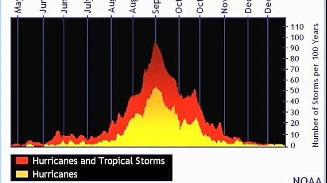
About 95% of the strongest hurricanes ranking Category 3 or higher come after Aug. 1 with the peak season heating up in mid-August and running through mid-October.
This hurricane season rolls off a year when no hurricanes made landfall in the U.S. — the first time that's happened in a decade.
Thursday's announcement also said NOAA forecasters predict a 75% chance for below-normal activity, with a 20% chance of a near-normal season, and just a 5% chance of above-normal activity.
Kimberly Miller is a journalist for the USA TODAY NETWORK FLORIDA. She covers weather, the environment and critters as the Embracing Florida reporter. If you have news tips, please send them to kmiller@pbpost.com. You can get all of Florida’s best content directly in your inbox each weekday by signing up for the free newsletter, Florida TODAY, at palmbeachpost.com/newsletters.
This article originally appeared on Palm Beach Post: NOAA's updated 2026 hurricane forecast has less storms, strong El Niño