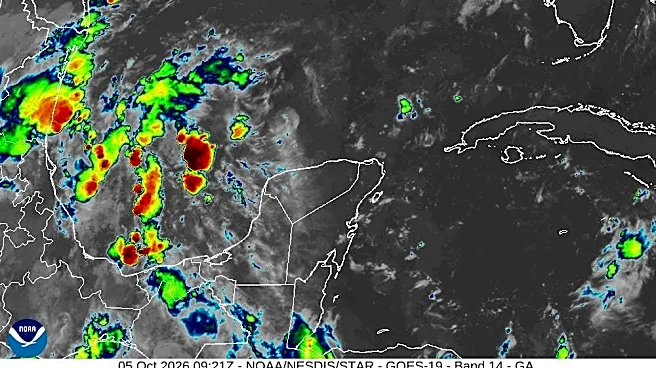






An area of low pressure in the Gulf of America is likely to become a tropical depression by the middle or later part of this week, according to the National Hurricane Center.
A stalled cold front is forecast to bring repeated rounds of flooding downpours throughout the Southeast this week, as eyes watch the Gulf.
➤ Track all active storms
Shop Amazon for hurricane supplies
The next name on the Atlantic hurricane list is Isaias.
Formerly the Gulf of Mexico, the Gulf of America was renamed by the Trump administration.
El Niño, a climate pattern in the Pacific, tends to bring wind shear into the Atlantic that helps prevent tropical storms and hurricanes from developing or strengthening.
We could set a new record this week. The latest first hurricane of
the season happened on Oct. 8, 1905, according to AccuWeather.
➤ Weather alerts via text: Sign up to get updates about current storms and weather events by location
If no hurricane at all develops by the end of hurricane season on Nov. 30, it'll be only the third time that's happened since record-keeping began in 1851.
That doesn't mean you shouldn't remain prepared. Warm coastal waters mean a tropical system could develop quickly and very close to land, leaving little time to prepare.
There have been no hurricanes and eight tropical storms in the Atlantic basin as of 8 a.m. Oct 5.
➤ Read more: Why October is still a significant hurricane threat for Florida
Is there a hurricane coming to Florida or Palm Beach County? See what forecasters are watching

No. There is no hurricane forecast to approach Florida as of 8 a.m. Oct. 5.
However, the National Hurricane Center said a tropical depression is likely to form in the Gulf later this week, and AccuWeather forecasters said the area of low pressure could become either a tropical depression or tropical storm.
Tropical depression or tropical storm could form in Gulf this week. Will it impact Florida or Palm Beach County?
A trough of low pressure in the southwestern Gulf of America is producing disorganized showers and thunderstorms.
Although environmental conditions appear to be marginally conducive, gradual development is becoming more likely, and a tropical depression is likely to form during the middle or latter portion of the week.
This system is expected to drift eastward over the next few days, before it turns northward.
- Formation chance through 48 hours: low, 30 percent
- Formation chance through 7 days: high, 70 percent.
"By later this week, a cluster of showers and thunderstorms in the southern Gulf and Bay of Campeche may organize into a tropical rainstorm and could eventually strengthen into a tropical depression or tropical storm," AccuWeather Senior Meteorologist Dan Pydynowski said.
"There is a reasonable chance, probably better than 50 percent that this does develop into at least a tropical depression," said meteorologist Matt Lanza with TheEyewall.com on Oct. 4.
"A track generally north or northeast seems reasonable as well, putting Louisiana through Floridaon some notice — not likely Texas. But I think what we are most confident in at this point is a heavy rain event for the Gulf Coast and Florida."
Rainy week ahead for Florida
The Southeast will face repeated rounds of flooding downpours much of this week as tropical moisture interacts with a stalled front, while a separate area of tropical moisture could organize along the Gulf Coast, according to AccuWeather meteorologists.
"An additional surge of tropical moisture is expected during the first half of the workweek across much of the Florida Peninsula as the stalled boundary shifts slightly south. With sufficient tropical moisture in place, heavy rainfall rates of 1-3 inches per hour will be possible.
"From Monday to Wednesday morning, 1-2 inches of rainfall is expected from Tampa through central Georgia and southern Alabama and across much of the Florida Panhandle. A corridor of 2-4 inches is forecast from Panama City to Jacksonville. Where the heaviest downpours persist, 4-8 inches is expected across part of northern Florida. The AccuWeather Local StormMax is 14 inches."
The rain isn't limited to North Florida and the Panhandle.
Heavy rain is possible each day this week, the National Weather Service Tampa Bay posted on X.
"A wet patternis expected to continue through much of thework week as a frontal boundary sinks southward and stalls over Central Florida," the National Weather Service Melbourne posted on X.
Rain chances increase during the week for South Florida.
Flood watches, warnings, advisories issued for parts of Florida
Florida weather radar for Oct. 5, 2026

Hurricane Center also watching 2 tropical waves
The NHC is tracking two tropical waves:
- A tropical wave is along 55W, south of 20N, moving westward at 11 to 17 mph.
- A tropical wave is over the western Caribbean with axis along 83W, south of 21N, moving westward at around 17 mph.
What do the colored, hatched areas on the NHC map mean?
The hatched areas on the National Hurricane Center's tropical outlook map indicate "areas where a tropical cyclone — which could be a tropical depression, tropical storm or hurricane — could develop," said National Hurricane Center Deputy Director Jamie Rhome.
➤ Hurricane Center is testing new cone: What's changing the season
The colors make it visibly clear how likely a system could develop, with orange medium and red high. In 2026, the tropical outlook will use a gray X to indicate disturbances with a low chance for development.
The National Hurricane Center generally doesn't issue tropical advisories until there is a named storm, but there is an exception.
"If a system is near land and there is potential for development, the National Hurricane Center won't wait before it issues advisories, even if the system hasn't become an actual storm. This gives residents time to prepare," Rhome said.
What is a disturbance?
The National Hurricane Center's tropical outlook map highlights "disturbances" in the Atlantic basin.
These are clusters of storms with some organization, but which don't have a defined circulation typical of tropical cyclones.
➤ Ready or not, National Hurricane Center resumes daily tropical outlooks
If shown on the tropical outlook map in orange or red, forecasters are predicting the potential of those disturbances into developing as medium or high, respectively.
Disturbances shown on the map with a gray x have little to no chance for development. This is a change from prior years which indicated such disturbances in yellow.
What is a tropical wave?
"Tropical waves are clusters of showers and thunderstorms that act as the seedlings for many tropical storms throughout the Atlantic season," said Alex DaSilva, AccuWeather lead hurricane expert, via email.
“There are about 60 tropical waves that move across the Atlantic each year, and roughly 10 percent to 15 percent of them develop into a tropical system. That’s about one in seven.
"Tropical waves are important because they contribute to about 80 percent of all major hurricanes."
Could 2026 be a year of no hurricanes for Florida, Atlantic basin?
If this year's Atlantic season has no hurricanes by Nov. 30, it will be only the third time it has happened based on records dating back to 1851, and you have to go back more than 100 years, to 1907 and 1914.
It is possible there were undocumented hurricanes, but records before the satellite era began in 1966 depended on observations from those nearby.
➤ A hurricane-free 2026 is within reach, but we're not in the clear yet
There is time, since the season doesn't end until Nov. 30, and waters near the U.S. keep the risk alive, according to AccuWeather.
Colorado State University predicting below-normal tropical activity for first half of October
In its two-week tropical forecast issued Sept. 30, Colorado State University is predicting below-normal activity, although "global model signals are hinting at potential for TC development in the southern Gulf in the 8-13 October timeframe."
Historically, the primary threat area for major hurricane formations for the first half of October "shifts farther to thewest, with formations picking up considerably in the western Caribbean."
CSU forecast for Sept. 30-Oct. 13:
- above-normal: 2%
- normal: 20%
- below-normal: 78%
When is hurricane season?
The Atlantic hurricane season runs from June 1 through Nov. 30.
Ninety-seven percent of tropical cyclone activity occurs during this time period, NOAA said.
➤ Hurricane Center testing new cone: What's changing this season?
The Atlantic basin includes the northern Atlantic Ocean, Caribbean Sea and Gulf of America, as the Gulf of Mexico is now known in the U.S. per an order from President Trump. NOAA and the National Hurricane Center are now using Gulf of America on maps and in advisories.
Countdown clock to end of 2026 Atlantic hurricane season
How many tropical storms, hurricanes are in a typical season?
The 30-year average, from 1991 to 2020, is 14 named storms, seven hurricanes and three major hurricanes.
When is the peak of hurricane season?

The peak of the season was Sept. 10, with the most activity happening between mid-August and mid-October, according to the Hurricane Center.
What are names for 2026 Atlantic hurricane season?
Here are the names for the 2026 Atlantic hurricane season and how to pronounce them:
- Arthur: Tropical Storm Arthur formed June 17, 2026
- Bertha: Tropical Storm Bertha formed July 20, 2026
- Cristobal: Tropical Storm Cristobal formed Aug. 12
- Dolly: Tropical Storm Dolly formed Aug. 27
- Edouard: Tropical Storm Edouard formed Sept. 1
- Fay: Tropical Storm Fay formed Sept. 20, Sept. 23, and Sept. 28
- Gonzalo: Tropical Storm Gonzalo formed Sept. 24
- Hanna: Tropical Storm Hanna formed Sept. 28
- Isaias, ees-ah-EE-ahs
- Josephine, JOH-seh-feen
- Kyle, KY-ull
- Leah, LEE-ah
- Marco, MAR-koe
- Nana, NA-na
- Omar, OH-mar
- Paulette, pawl-LET
- Rene, re-NAY
- Sally, SAL-ee
- Teddy, TEHD-ee
- Vicky, VIH-kee
- Wilfred, WILL-fred
Interactive map: See how many hurricanes, tropical storms have passed near your home
Stay informed. Get weather alerts via text
What's next?
We will continue to update our tropical weather coverage to bring you the most current information you need to protect your home and family.
This story has been updated to include new information.
Cheryl McCloud is a journalist for the USA TODAY Network-Florida's service journalism Connect team. You can get all of Florida’s best content directly in your inbox each weekday day by signing up for the free newsletter, Florida TODAY, at naplesnews.com/newsletters.
This article originally appeared on Palm Beach Post: Weather. NHC warns tropical depression could form this week in Gulf
Our editors independently choose our recommendations. Some content is produced with paid support from a third party, however our editorial decisions remain independent. If you buy through our links, the USA TODAY Network may earn a commission. Prices and availability may change.