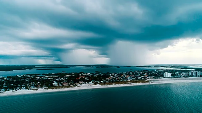


Spitting rain and shuddering thunderstorms will dampen Labor Day weekend statewide with periodic bouts of showers sending backyard barbecuers and theme park revelers scattering.
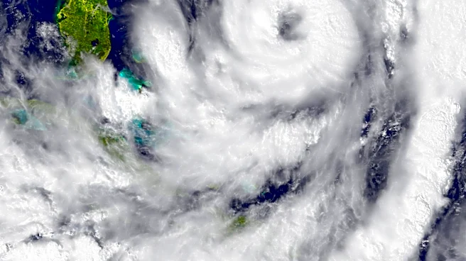
There’s no expectation of a days-long total washout. But bits of energy in the atmosphere leftover from the fleeting Tropical Storm Dolly, two troughs sandwiching the state in the Gulf and in the Atlantic, and an approaching cool front have meteorologists warning of the potential forlocalized flooding and temperatures that will remain above normal under patches of sunshine.
“It’s going to be hot and steamy,” said AccuWeather forecaster Alex DaSilva. “If anyone is spending time outside, they should have a backup plan and know where to go if there is a thunderstorm.”
The
Weather Prediction Center has rainfall totals of up to 2.5 to 3 inches through Labor Day (Monday, Sept. 7) in areas of the Panhandle to about Gainesville.
Farther down the Peninsula, widespread rainfall could reach 3 to 4 inches with isolated amounts of 4 to 6 inches in the most southern reaches of the state through Monday.
There is also a marginal risk of excessive rainfall statewide into Sept. 6 with the risk shifting to the Panhandle and North Florida on Sept. 7. A marginal risk is the lowest level on the Weather Prediction Center’s four-tier scale. It means there is about a 5% chance of rainfall that could cause flash flooding.
“We’re going to stay wet, we’ll have plenty of moisture, and we’ll see that scattered shower and thunderstorm activity into next week,” said National Weather Service Tampa Bay meteorologist Stephen Shiveley.
How bad will Florida rip currents be Labor Day weekend?
For beachgoers, the thunderstorms may be the biggest threat. The risk of rip currents is low along the lower southeast and much of the Gulf Coast. A moderate risk may remain along the Treasure Coast through Jacksonville and in the central Panhandle.
One caveat mentioned in multiple forecasts are weather models that nudge the Bermuda High over the state during the weekend. That could introduce drier air and decrease cloud cover, but it could also increase afternoon thunderstorms.
The soggy weather may hinder some weekend plans, but it’s a benefit for areas of Florida still trying to shrug off a stubborn droughtthat has persisted through the wet season. The wet season typically runs between mid-May and mid-October.
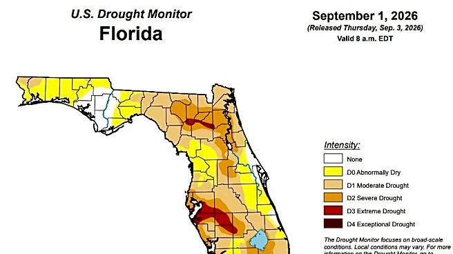
A report issued Sept. 3 by the U.S. Drought Monitor shows 62% of the state in some stage of drought with another 25% considered “abnormally dry.”
The most extreme drought is in the Tampa Bay area and spreading southeast into DeSoto and Highlands counties.
“This is one of the driest years we’ve had on record, just above the 2011 situation,” said South Florida Water Management District Bureau Chief Cassondra Armstrong during an Aug. 13 meeting.

In 2011, the City of West Palm Beach, which relies on surface water, was so low on water supply it asked restaurants to only give glasses of water to customers who requested them. Condominiums were asked to turn off fountains, and at one point, the city told water managers it had only 22 days of water left.
“There’s just not a lot of water in the system,” Armstrong said about the current drought.
What Florida cities could use the most rain?
Florida suffered a dry summer nearly statewide except for portions of the Treasure and Space coasts and near the far western Panhandle, which all saw lightly above average rainfall amounts.
Elsewhere, it was parched.
Fort Lauderdale and Sarasota were down about 15 inches of rain from a normal June through August period, according to the Southeast Regional Climate Center. Miami had a 14.7-inch deficit, Marco Island was down 10.7 inches, and West Palm Beach had an 8-inch deficit.
Other areas with lower-than-normal rain amounts included Naples (-9.4), Fort Myers (-8.5), Orlando (-6.38), Ocala (-5) and Tallahassee (-5.1).
Shiveley said the rain through Labor Day will continue to help with short-term drought conditions.
“The long-term drought, unfortunately is still around. Our rivers are low, our reservoirs are low,” he said. “We still need some more rain to bounce back.”
The unusually dehydrated summer was a boonto Lake Okeechobee, allowing for lower water levels that let the sun reach submerged plants and gave state officials a chance to dredge lifeless muck off sandy lake bottoms and do controlled burns.
But deeper in the Everglades watershed that leads to Florida Bay, the dry conditions left acres upon acres desiccated that are normally glistening wet and ready for fish to breed for wading bird season.
Areas where a great colony of ibis normally nest had water levels in mid-August that were three feet below what is needed for their prey to flourish. In Taylor Slough, a rut of wetland feeding freshwater to Florida Bay, water levels were 5 inches below normal allowing harmful salinity levels to increase in the bay.
There is also a risk of peat fires, soil oxidation and vegetation loss. And although it’s been raining on the coasts with sea breeze triggered thunderstorms, that water flows largely to the ocean, not inland.
Meteorologist Christopher Fisher with the NWS office in Miami said Sept. 3 that the drought lessened from extreme to severe in the Everglades.
“We’re not out of the woods yet but we’ll take whatever good news we can get with the drought at this point,” Fisher said. “We still have along way to go. We still have a deficit.”
A strong El Niño could bring a wet winter to Florida
Absent a tropical storm, water managers in South Florida are banking on the strong El Niño to bring heavy rains this winter and replenish water supplies.
"If this doesn't occur we may be facing the possibility of dealing with regional water shortage restrictions at some point this coming dry season," said Lake Worth Drainage District Executive Director Tommy Strowd.
El Niño climate patterns help squash tropical cyclones in the Atlantic basin during hurricane season, but can mean a stormier cooler winter as the drops into the lower latitudes across the southern reaches of the U.S.
The lower jet stream whips winter storms closer to Florida with higher chances of rain-toting cold fronts pushing through the state.
“The projections are still pointing toward a super El Niño,” said John Mitnik, chief engineer at the South Florida Water Management District, at the Aug. 13 meeting. “That’s what, quite frankly, we will need in order to sustain the regional system through the remainder of the dry season.”
The dry season runs from about mid-October to mid-May.
Kimberly Miller is a journalist for the USA TODAY NETWORK FLORIDA. She covers weather, the environment and critters as the Embracing Florida reporter. If you have news tips, please send them to kmiller@pbpost.com. You can get all of Florida’s best content directly in your inbox each weekday by signing up for the free newsletter, Florida TODAY, at palmbeachpost.com/newsletters.
This article originally appeared on Palm Beach Post: Labor Day weekend plans will pay a price for easing Florida's drought