



An idling cold front will assail an already damp Florida the first week of October with a chaos of showers stretching from the western Panhandle through the sawgrass marshes of the Everglades.
The front, whichis forecastto drift into the northern reaches of the state late Sunday into Monday before stuttering mid-Peninsula, promises slightly cooler temperatures as clouds menace, retreat and return.
Parts of the state have been socked in by wooly heat index, or “feels like”, temperatures in the 90s and triple digits as surges of warm tropical moisture push in from the south. The heat index temperature Oct. 2, in Naples is forecast to hit 106 degrees. Central Florida heat indices are forecast to reach the low 100s Friday.
National Weather Service
meteorologist Jasmine Montgomery said Tallahassee should expect an average of up to 3 inches of rain with 4-plus inches west of the capital through the weekend.
“Then we do get a cool front Monday and that’s why we have the rain sticking around and continuing through mid-week,” she said.
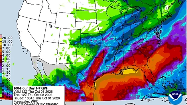
The Weather Prediction Center is forecasting seven-day rainfall amounts as high as 10 inchesin a stretch of the coastal Panhandle with amounts reducing toward lower latitudes.
Central Florida could get between 3 and 5 inches through Oct. 8.
How much rain will South Florida get?
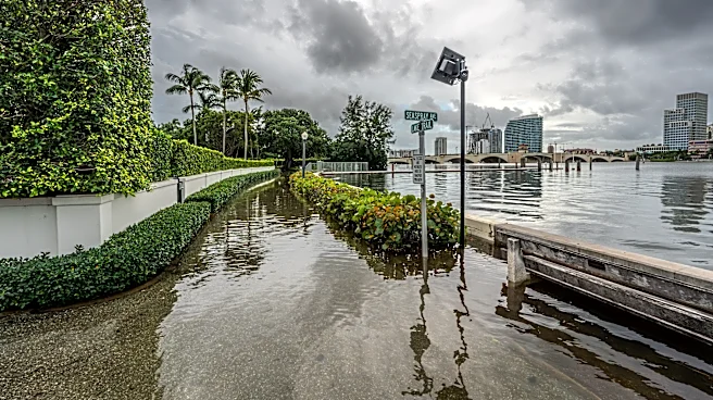
South Florida is forecast by the WPC to see between 2 and 4 inches in addition to an Oct. 1 deluge that came with a 46 mph wind gust at Donald J. Trump International Airport and coastal flood statements from a lingering king tide.
“I do have some bad news,” said AccuWeather meteorologist Alex DaSilva. “We’ll have this wet flow from the south through the weekend and then this cold front will stall across Central and North Florida that will mean repeated rounds of showers through the week.”
Jacksonville NWS meteorologists said there is still uncertainty in the forecast but that the cold front could trigger a local nor'easter with wind gusts of up to 50 mph, rounds of heavy rain, dangerous surf conditions, and minor to moderate beach erosion.
While Floridians may frown on a spike in sogginess, there remains a stubborn drought in portions of the state as it approaches the mid-month end of the wet season. The rainy season lasts from about mid May to mid October.
About 50% of the state is in moderate to severe drought with pockets of extreme drought in the Tampa area, a spot northwest of Lake Okeechobee and in the central Panhandle, according to a U.S. Drought Monitor report released Oct. 1.
Coastal areas from the Space Coast through Miami-Dade County are mostly free of drought or considered only “abnormally dry.”
Some cities accrued a deficit of rainfall in September, including West Palm Beach, which got nearly 4 inches more rain than normal, and Fort Lauderdale, which was up a jaw-dropping 14 inches for the month, according to the Southeast Regional Climate Center. Sarasota also had a surplus of 4 inches of rain last month.

But other areas were down. Tallahassee had a deficit of 3 inches, Fort Myers was down nearly 4 inches and Daytona Beach was 5 inches below normal.
“The moisture is going to be pretty deep,” said Melbourne-based NWS meteorologist Tim Sedlock about the week's forecast. “It’s unusually moist.”
For South Florida, the highest chances for rain were Thursday, followed by days of showers, and potential thunderstorms that could come more in a summer-like pattern with the afternoon heat and sea breezes triggering rain.
The El Niño winter: Get used to the Florida rain
Andy Hazelton, a scientist at the University of Miami's Cooperative Institute for Marine and Atmospheric Studies, said on social media that the weather pattern is “probably a pretty good preview of our El Niño winter.”
“That’s why these winters are cooler on average: cloudiness keeps the high temperatures way down even without big cold outbreaks,” he said.
AccuWeather is watching the pending cold front for the low potential that something tropical may try to spin up from it. This time of year, home grown tropical systems can grow off frontal boundaries.
But it is also looking more closely at a spot in the southwestern Gulf and Bay of Campeche for something to develop.
Florida State climatologist Emily Powell said sea surface temperatures in the Gulf are record warm for this time of year, offering plenty of fuel for anything that makes a run at tropical cyclone status.
“The Climate Prediction Center is watching an area around the Yucatan for potential development but that is still a big question mark because we aren’t sure if anything will be able to develop,” Powell said. “There may be enough wind shear that it won’t get its act together.”
The National Hurricane Center had nothing on its seven-day tropical weather outlook in that area as of mid-day Oct. 1.
Kimberly Miller is a journalist for the USA TODAY NETWORK FLORIDA. She covers weather, the environment and critters as the Embracing Florida reporter. If you have news tips, please send them to kmiller@pbpost.com. You can get all of Florida’s best content directly in your inbox each weekday by signing up for the free newsletter, Florida TODAY, at palmbeachpost.com/newsletters.
This article originally appeared on Palm Beach Post: With upcoming El Niño winter, get used to all this rain in Florida