


Isaias wasn’t the endof hurricane season with models sniffing around a potential tropical twist off the Carolinas but the home stretch to Nov. 30 is expected to be more of a lull than a spasm.
A hurricane dimming El Niño has continued to escalate, reducing the chances for abackloaded season where storms rampage through November.
“Backloaded means the Caribbean and this year the shear there is through the roof,” said Colorado State University hurricane researcher Phil Klotzbach. “I had to change my graphics color scheme to measure shear because it was just too much and maxing out the scale.”
CSU’stropical forecastthrough Oct. 27 calls for a 60% chance of below normal activity, with a 38% chance of normal activity. There is just a 2% chance that
the Atlantic basin will be spunkier than normal.
The forecast mentions a weak signal for a system forming in the subtropics next week as the globe-circling Madden-Julian Oscillation makes its way into a position to instigate Atlantic-basin storms.
National Hurricane Center forecasters had nothingmarked on their maps for the next seven days as of Oct. 15.
But AccuWeather and WPLG TV meteorologist Michael Lowry noted that several computer models, including the heralded Google DeepMind AI model, were looking at an area of low pressuredeveloping along a stalled front off the Carolinas next week.
“The starting bid from forecast models is generally low (roughly 30% development odds), though the European model is taking a slightly more bullish stance, indicating a modest 40% to 50% chance of development,” Lowry wrote in his Eye on the Tropics column.
The timeframe would be in the range of Oct. 20 to Oct. 23.
What are the chances of a late October hurricane in Florida?

Late October hurricane landfalls in Florida are infrequent but there have been some doozies.
- In 1950, Cat 4 Hurricane King whacked Miami on Oct. 18.
- An unnamed Cat 2 landed south of Sarasota on Oct. 19, 1944. And a 1906 no-name hurricane hit the middle Keys as a Cat 3, swept through Miami, then did a U-turn off the coast of South Carolina and hit Jacksonville as a tropical storm on Oct. 21.
- Hurricane Wilma made landfall on Oct. 24, 2005, on the southwest coast near Cape Romano as a Category 3 storm.
“You don’t sleep on the Gulf in October,” said Weather Channel on camera meteorologist and hurricane expert Rick Knabb in an interview ahead of Isaias. “The season is not over yet and I just don’t trust the Gulf or the warm waters around Florida.”
Klotzbach said many later-season storms that hit Florida, including Isaias, 2024’s Hurricane Milton and 2018's Michael, formed from the Central American Gyre. The gyre is a large area of low pressure near the Yucatan Peninsula that bookends hurricane season but is most potent in the fall when waters are warmest.
“Five days before Isaias, there was a big area of rotation there,” Klotzbach said about the gyre. “There's just not much circulation there now.”
How many November hurricanes have hit Florida?
November hurricanes are even more rare than those in the latter part of October, with just three making landfall in the Sunshine State dating back to the 1800s.
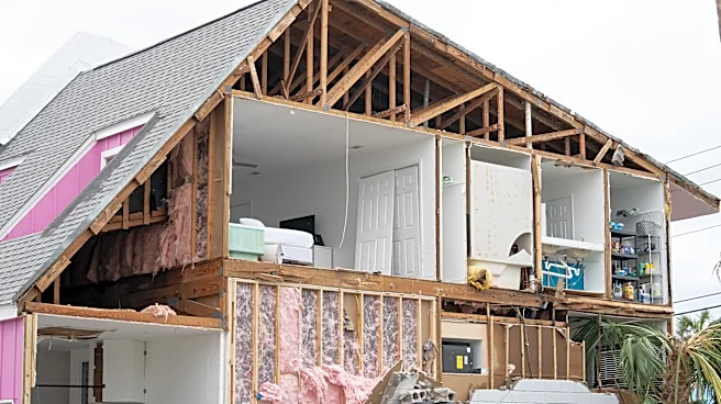
- Most recently, 2022’s sprawling Hurricane Nicole made landfall near Vero Beach on Nov. 10 as a Category 1 storm. Up to 5 feet of storm surge flooded Florida’s central and northeast coast, taking out beachfront buildings and homes. The National Centers for Environmental Information estimated the damage form Nicole at $1 billion.
- In 1985, Hurricane Kate made landfall near the Panhandle’s Mexico Beach as a Category 2 storm on Nov. 21, just four days ahead of Thanksgiving.
- The third November hurricane to hit Florida was the 1935 storm known as the Yankee because of its unusual approach from the north.
The Yankee was born near Bermuda, rode the underbelly of the Bermuda High toward the coast of the Carolinas, but was then picked up by the clockwise swoop of another high-pressure system that pushed it into Miami on Nov. 4 as a Category 2 hurricane.
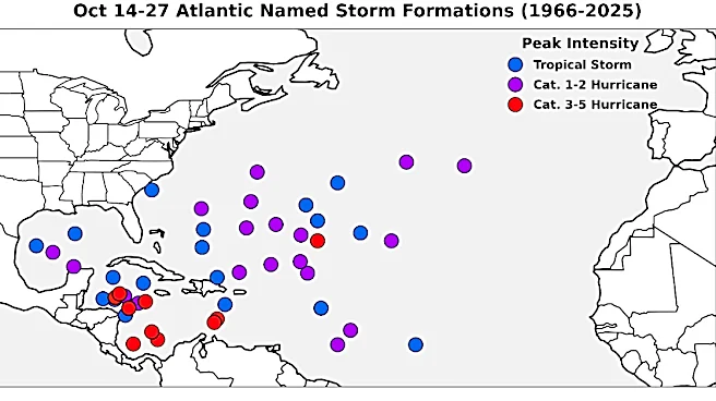
All of the November hurricanes, as well as Wilma, were born in the Caribbean, which is so heavily sheared it would be hard for something to get a foothold there this year, Klotzbach said. Melissa, a Category 5 hurricane that hit Jamaica last year on Oct. 28, was also a Caribbean-formed storm.
The Climate Prediction Center’s most recent El Niño forecast says there’s an 83% chance for a strong to very strong event that could last atleast through January. It notes that there’s a high likelihood that this El Niño will surpass all other events for strength dating back to 1950.
Klotzbach is already looking to next hurricane season when there will be no El Niño to guard against hurricanes and plenty of simmering sea surface temperatures to feed the storms that form. El Niño creates sinking air in the Atlantic, which dries and warms as it makes its way to the surface. That means fewer clouds to block out the blazing sun.
“There are just no clouds and that should continue through winter,” Klotzbach said. “In the words of Samuel Jackson in "Jurassic Park"; ‘Hold onto your butts.’”
Kimberly Miller is a journalist for the USA TODAY NETWORK FLORIDA. She covers weather, the environment and critters as the Embracing Florida reporter. If you have news tips, please send them to kmiller@pbpost.com. You can get all of Florida’s best content directly in your inbox each weekday by signing up for the free newsletter, Florida TODAY, at palmbeachpost.com/newsletters.
This article originally appeared on Palm Beach Post: Florida's hurricane risk is fading but the season's not over yet