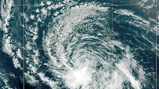





Almost four months after the start of hurricane season, there's something brewing in the tropics − and forecasters are monitoring at least three tropical waves in the Atlantic.
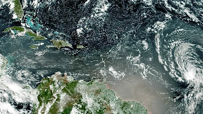
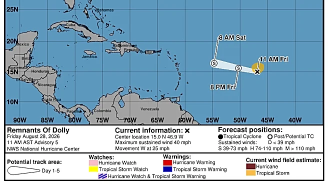
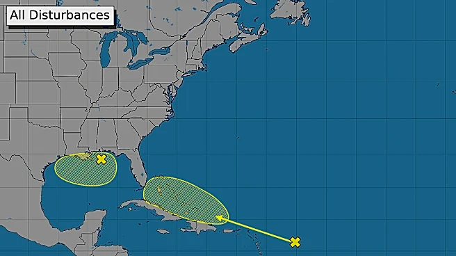
According to the 8 a.m. Saturday, Aug. 29, 2026, tropical weather outlook from the National Hurricane Center in Miami, Florida, there are two disturbances that experts are monitoring, including the remnants of Tropical Storm Dolly, which briefly formed Thursday, Aug. 27, 2026, before being downgraded to a tropical system a day later. Showers and thunderstorms are associated with a weak area of low pressure about 100 miles from Pensacola, Florida, though experts at the NHC say development would be slow.
Will the next storm form?
➤Track all active storms
Shop Home Depot for
hurricane prep
Arthur, the first named storm of the hurricane season, briefly strengthened into tropical storm status June 17, 2026, before the hurricane center downgraded it to a disturbance not long after. Tropical Storm Bertha formed more than a month later − July 20, 2026, made its second landfall three days later near the Texas-Louisiana border, and quickly weakened. Tropical Storm Cristobal, the third-named system, formed earlier this month.
In a sheer coincidence, Tropical Storm Dolly formed two days after the death of country music icon Dolly Parton.
As the world mourns Dolly Parton, those in Florida and the Southeastern U.S. were keeping an eye on the now-defunct Tropical Storm Dolly.
Dolly Parton, the undisputed queen of country music and a pop culture legend, died Tuesday, Aug. 25, 2026, at age 80. Two days later, Tropical Storm Dolly formed in the open Atlantic before being downgraded, the National Hurricane Center reported.
There have been no other named storms so far into the third month of the 2026 Atlantic hurricane season.
In 2025, no storms made landfall in the U.S. during hurricane season, but it was an active one.
The hurricane center graphics and live weather radars below show what's swirling in the tropics (if anything) as well as the conditions for potential rain, flash flood and other warnings.
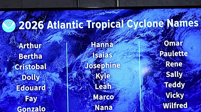
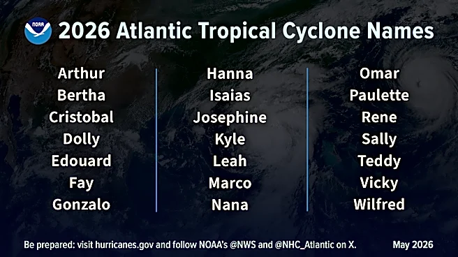
Atlantic hurricane season is from June 1 to Nov. 30 every year, with the most activity between August and October. Should a weather system develop into a tropical storm, the fifth system would be named Edouard, shown on the list of the 2026 Atlantic hurricane season names below.
The hurricane center resumed its tropics advisories ahead of hurricane season − on May 15.
➤ Weather alerts via text: Sign up to get updates about current storms and weather events by location
Keep reading for information about tropical storm activity for Saturday, Aug. 29, 2026.
National Hurricane Center in Miami, Florida, forecast on tropical activity: Is there a tropical storm or hurricane now?
According to the Saturday, Aug. 29, 2026, tropical outlook from the National Hurricane Center in Miami, Florida, forecasters were keeping watch on two systems, one east of the Leeward Islands and another in the northeastern and north-central Gulf. The graphic above automatically updates with the most recent location for any or all disturbances. The NHC reported:
East of the Leeward Islands (remnants of Dolly), shown in yellow: Showers and thunderstorms have increased this morning in association with the remnants of Tropical Storm Dolly, located several hundred miles east of the Leeward Islands. However, there are no signs that the system is developing a closed circulation. Redevelopment of this system is unlikely while it moves westward to west-northwestward near 25 mph. The wave could bring locally heavy rains and gusty winds to portions of the Leeward Islands, the Virgin Islands and Puerto Rico over the next several days.
- Formation chance through 48 hours was low near 0 percent.
- Formation chance through 7 days was low near 10 percent.
Northeastern and north-central Gulf of America, formerly called the Gulf of Mexico, shown in yellow: Disorganized cloudiness and showers over portions of the northeastern and north-central Gulf of America are associated with a weak area of low pressure centered about 100 miles south-southwest of Pensacola, Florida. Development, if any, of this system is expected to be slow while it drifts westward for the next few days.
Moderate to locally fresh easterly winds and seas of 2-4 feet are noted in the Bay of Campeche, while weaker winds and slight seas prevail elsewhere.
For the forecast, the weak area of low pressure over the northern Gulf waters was producing scattered showers and isolated thunderstorms. These storms may produce gusty winds and higher seas. This system is expected to remain nearly stationary over the next several days.
- Formation chance through 48 hours was low near 0 percent.
- Formation chance through 7 days was low at 10 percent.
In addition, the National Hurricane Center was tracking these tropical waves on Saturday, Aug. 29, 2026:
- A tropical wave was along 32W, south of 16N, moving westward at around 15 knots. No significant convection was noted near this wave.
- A tropical wave was over the eastern Caribbean, along 67W, south of 17N, moving westward at 15-20 knots. Scattered moderate convection was noted from 13N to 18N between 64W and 70W.
- A tropical wave was over the western Caribbean, along 81W, south of 21N, moving westward at 15-20 knots. Scattered showers and isolated thunderstorms were evident in SW Caribbean.
The Atlantic basin consists of the northern Atlantic, Caribbean Sea and Gulf of America. NOAA changed its naming convention for the Gulf of Mexico after the U.S. Geological Survey changed the name on U.S. maps per President Trump's order.
The USA TODAY Network in Florida will produce daily tropics watch advisories.
- 2026 Atlantic hurricane season predictions
Is it raining in Florida today? Live weather radar
Shown is the National Weather Service radar, which shows conditions in real-time for the Southeast United States and parts of Central Florida. The current date and time show up on the bottom right of this radar embed; otherwise, you may need to clear your cache.
Weather watches and warnings issued in Florida
What are the 2026 Atlantic hurricane season names? Did your name make the hurricane season names list?
Since 1953, the National Hurricane Center has released a list of names in alphabetical order for Atlantic tropical storms before each season begins, which it recycles every six years. It retires names of storms that are excessively deadly or costly, if it would be insensitive or inappropriate to use them again. These are the 2026 Atlantic tropical cyclone names:
Arthur, which formed as a tropical storm June 17, 2026Bertha, which formed as a tropical storm July 20, 2026Cristobal, which formed as a tropical storm Aug. 12, 2026Dolly, which formed as a tropical storm Aug. 27, 2026- Edouard
- Fay
- Gonzalo
- Hanna
- Isaias
- Josephine
- Kyle
- Leah
- Marco
- Nana
- Omar
- Paulette
- Rene
- Sally
- Teddy
- Vicky
- Wilfred
Interactive map: Hurricanes, tropical storms that have passed near your city
Stay informed. Get weather alerts via text
What's next?
We will provided tropical weather coverage daily until Nov. 30 to keep you informed and prepared. Download your local site's app to ensure you're always connected to the news. And look for our special subscription offers here.
Contributing: Cheryl McCloud and Olivia Franklin, USA TODAY Network-Florida
This article originally appeared on Palm Beach Post: Hurricane center tracking 2 systems, including remnants of Tropical Storm Dolly
Our editors independently choose our recommendations. Some content is produced with paid support from a third party, however our editorial decisions remain independent. If you buy through our links, the USA TODAY Network may earn a commission. Prices and availability may change.