


As Palm Beach County continues to suffer under extreme hot weather, with heat advisories issued across the entire state and peak heat indices of up to 115 degrees forecast in the northeastern part of Florida on Saturday, Aug. 15, tropical activity is picking up in the Atlantic.
The National Hurricane Center is monitoring two disturbances, but chances of formation are low.
Invest 94L in the Atlantic has a 10% chance of development over the next week, and Invest 92L in the Southeastern Caribbean Sea currently has a near 0% chance of formation in the next seven days, according to the latest update from the National Hurricane Center in Miami.
➤ Weather alerts via text: Sign up to get updates about current storms and weather events by location
The hurricane
center is monitoring four additional tropical waves, which can act as seedlings for tropical storms.
While this season is expected to see below-normal activity due to a strong El Niño and there's no tropical threat to the Sunshine State at this time, conditions can change rapidly. Forecasters encourage Florida residents to stay prepared.
Shop Amazon for hurricane prep
Here's what you should know based on the latest advisory from the National Hurricane Center as of 8 a.m., Aug. 15.
Invest 92L could impact Lesser Antilles with wind, rain Saturday
Special note on the NHC cone: The forecast track shows the most likely path of the center of the storm. It does not illustrate the full width of the storm or its impacts, and the center of the storm could travel outside the cone. In 2026, the Hurricane Center will experiment with a new cone to include 90% of forecast track possibilities instead of the previous 67% forecast error.
➤ Track Invest 92L
➤ Six Florida counties make top 10 list as most vulnerable to hurricanes
Invest 92L: A tropical wave over the southeastern Caribbean Sea is producing gusty winds and an area of disorganized showers and thunderstorms. Development of this system is not expected due to strong upper-level winds and dry air. Gusty winds and areas of heavy rain are still possible across portions of the Lesser Antilles today.
- Formation chance through 48 hours: low, 0 percent.
- Formation chance through 7 days: low, 0 percent.
Invest 92L spaghetti models
Special note about spaghetti models: Illustrations include an array of forecast tools and models, and not all are created equal. The Hurricane Center uses only the top four or five highest performing models to help make its forecasts.
Invest 94L: Limited development possible over next day or two
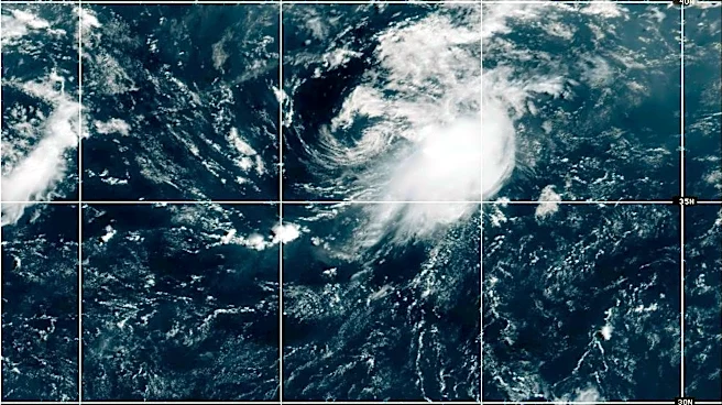
Invest 94L: A tropical wave over the central tropical Atlantic about midway between the Cabo Verde Islands and the Lesser Antilles continues to produce disorganized showers and thunderstorms.
Limited development of this system is possible over the next day or two before the system encounters strong upper-level winds to the east of the Lesser Antilles.
- Formation chance through 48 hours: low, 10 percent
- Formation chance through 7 days: medium, 10 percent
Invest 94L spaghetti models
What is an invest?
Short for investigation,the National Hurricane Center uses the term invest for areas of low pressure it is monitoring for potential development into a tropical depression or storm.
Invests are not tropical depressions or tropical storms. They're usually clusters of showers and thunderstorms, and just because they've been designated as an invest does not guarantee they'll strengthen into a tropical storm or hurricane.
Invests run from 90 to 99, followed by a letter:L for the Atlantic basin and E for those in the eastern Pacific. After 99, it starts over again and the next invest would be 90.
Once something has been designated as an invest, specialized data sets and computer modelscan begin, including scheduling Hurricane Hunter aircraft missions and running spaghetti models.
NHC tracking 2 disturbances, 4 waves in Atlantic basin
Along with Invests 92L and 94L, the National Hurricane Center is monitoring four additional tropical waves Saturday, Aug. 15.
- A tropical wave extends from 04N to 20N with axis near 23W, moving westward at 10-15 kt. Scattered moderate convection is from 06N to 14N between 22W and 32W.
- A tropical wave extends from 04N to 20N with axis near 39W, moving west at around 10-15 kt. Scattered moderate convection is noted from 06N to 14N between 38W and 48W.
- A tropical wave is in the E Caribbean south of 20N with axis near 62W, moving westward at around 15-20 kt. Scattered moderate convection extends from 08N to 17N between 56W and 66W.
- A tropical wave is in the far W Caribbean with axis near 83W, moving westward at about 15 kt. Scattered moderate convection is in the Gulf of Honduras.
What is a tropical wave?
"Tropical waves are clusters of showers and thunderstorms that act as the seedlings for many tropical storms throughout the Atlantic season," said Alex DaSilva, AccuWeather lead hurricane expert, via email.
“There are about 60 tropical waves that move across the Atlantic each year, and roughly 10 percent to 15 percent of them develop into a tropical system. That’s about one in seven.
"Tropical waves are important because they contribute to about 80 percent of all major hurricanes."
When is hurricane season in Florida?
The Atlantic hurricane season runs from June 1 through Nov. 30.
Ninety-seven percent of tropical cyclone activity occurs during this time period, NOAA said.
➤ Hurricane Center testing new cone: What's changing this season?
The Atlantic basin includes the northern Atlantic Ocean, Caribbean Sea and Gulf of America, as the Gulf of Mexico is now known in the U.S. per an order from President Trump. NOAA and the National Hurricane Center are now using Gulf of America on its maps and in its advisories.
What do the colored, hatched areas on the NHC map mean?
The hatched areas on the National Hurricane Center's tropical outlook map indicate "areas where a tropical cyclone — which could be a tropical depression, tropical storm or hurricane — could develop," said National Hurricane Center Deputy Director Jamie Rhome.
➤ Hurricane Center is testing new cone: What's changing the season
The colors make it visibly clear how likely a system could develop, with orange medium and red high. In 2026, the tropical outlook will use a gray X to indicate disturbances with a low chance for development.
The National Hurricane Center generally doesn't issue tropical advisories until there is a named storm, but there is an exception.
"If a system is near land and there is potential for development, the National Hurricane Center won't wait before it issues advisories, even if the system hasn't become an actual storm. This gives residents time to prepare," Rhome said.
Florida and Palm Beach County weather radar for Aug. 15, 2026

Florida weather watches and warnings
2026 hurricane names
Here are the names for the 2026 Atlantic hurricane season and how to pronounce them:
Arthur: Tropical Storm Arthur formed June 17, 2026Bertha: Tropical Storm Bertha formed July 20, 2026Cristobal: Tropical Storm Cristobal formed Aug. 12, 2026- Dolly, DAH-lee
- Edouard, eh-DWARD
- Fay, fay
- Gonzalo, gohn-SAH-loh
- Hanna, HAN-uh
- Isaias, ees-ah-EE-ahs
- Josephine, JOH-seh-feen
- Kyle, KY-ull
- Leah, LEE-ah
- Marco, MAR-koe
- Nana, NA-na
- Omar, OH-mar
- Paulette, pawl-LET
- Rene, re-NAY
- Sally, SAL-ee
- Teddy, TEHD-ee
- Vicky, VIH-kee
- Wilfred, WILL-fred
Stay informed. Get weather alerts via text
What's next?
We will continue to update our tropical weather coverage to bring you the most current information you need to protect your home and family.
Kim Luciani is a journalist for the USA TODAY Network-Florida's Audience team. You can get all of Florida’s best content directly in your inbox each weekday by signing up for the free newsletter, Florida TODAY, at https://tcpalm.com/newsletters.
This article originally appeared on Palm Beach Post: Tropics update Aug. 15: What Florida hurricane center is tracking