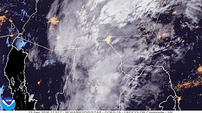







El Paso is seeing a soaking start as a surge of tropical moisture from Hurricane Polo fuels thunderstorms and heavy rain across the region.
The National Weather Service in El Paso
issued a Flash Flood Warning for El Paso County early Wednesday, Sept. 23, after radar indicated thunderstorms producing heavy rain. Between 1 and 1.5 inches of rain had fallen in the warned area by 3:02 a.m. MDT, with another 0.5 to 1.5 inches possible.The warning included West El Paso, Central El Paso, Northeast El Paso, East El Paso, Far East El Paso, Mission Valley, Horizon City, Clint, Anthony, Santa Teresa, Sunland Park, Canutillo and San Elizario.
The warning was set to expire at 6 a.m. MDT, but additional rounds of rain and thunderstorms are expected Wednesday,
Sept. 23.
Shop Amazon for weather supplies
Why is El Paso getting so much rain?
A late-September surge of tropical moisture is moving north into the region ahead of an upper-level trough off the West Coast.
The National Weather Service said precipitable water, a measure of atmospheric moisture, reached 1.29 inches in an overnight weather balloon observation. That is helping thunderstorms produce heavy rainfall as several atmospheric features come together to support storm development.
The weather service said the heaviest part of the event was expected to occur overnight into Wednesday morning, with storm activity continuing through the day.
How much rain could El Paso get?
The heaviest rainfall is expected to remain focused east and north of El Paso, across parts of Doña Ana and Sierra counties. But forecasters said the sharp boundary between the heaviest rain and lower rainfall totals was close enough to El Paso to be concerning.
Forecast guidance had shown 2 to 3 inches possible around Las Cruces, with isolated amounts of 4 inches or more.
For El Paso, the primary concern is not necessarily widespread extreme rainfall totals but intense thunderstorms capable of producing rapid flooding, especially in urban areas and places with poor drainage.
Is a hurricane bringing moisture to El Paso?
The Weather Prediction Center said tropical moisture is being pulled northward ahead of an upper-level trough. That moisture is one part of a larger atmospheric setup producing thunderstorms across southern New Mexico and Far West Texas.
How long will the rain last?
The heaviest flooding threat is expected through Wednesday morning, Sept. 23, but the chance of storms will continue through Friday.
The weather service expects the focus of the heavier rain to shift northeastward during the day Wednesday, with Sierra and Otero counties becoming more likely to see storms.
El Paso could still see additional showers and thunderstorms Wednesday afternoon and Thursday, although the overall flooding threat is expected to gradually decrease.
Drier conditions are expected to return by the weekend, followed by warmer temperatures.
Texas weather radar
Texas weather watches and warnings
Stay informed. Get weather alerts via text
Brandi D. Addison covers weather across the nation as the Weather Connect reporter for the USA TODAY Network and contributes to Texas Connect coverage across the state. She can be reached at baddison@usatodayco.com. Follow her on Facebook here.
This article originally appeared on El Paso Times: Hurricane Polo dumps heavy rain on El Paso, flooding roads: Weather tracker
Our editors independently choose our recommendations. Some content is produced with paid support from a third party, however our editorial decisions remain independent. If you buy through our links, the USA TODAY Network may earn a commission. Prices and availability may change.