







El Paso and the surrounding region remain under a flood watchas multiple rounds of storms are expected to bring heavy rainfall and the potential for flash flooding.
Rain chances are expected to increase Tuesday, Sept. 22, peaking around 6 p.m. and continuing overnight. El Paso faces about a 90% chance of rain during the evening hours, according to the National Weather Service.
Repeated rounds of storms could mostly impact low-lying areas, arroyos and flood-prone roads. Parts of El Paso, Las Cruces, Hatch and Truth or Consequences are under a moderate risk for flash flooding on Tuesday, meaning there is about a 40% chance of flash flooding within the affected area.
The threat of flash flooding is expected to ease somewhat Wednesday, Sept. 23, when
the risk drops to at least 15%.
EPISD cancels some after school activities
El Paso ISD posted on its social media that all after school activities are canceled for Tuesday, Sept. 22.
High school volleyball and after-school day care at all El Paso ISD Extended Day Learning campuses remain in place, as scheduled.
El Paso roads begin to become wet, slick

El Paso roads are already seeing the impact and signs of possible flooding as storms hit the Borderland.
Road conditions are starting to become a concern for motorists as several high-traffic streets have already started to see rainwater causing water building up and slick roads.
"Rain is already affecting many locations," Texas Department of Transportation officials posted on social media. "If you can’t delay your drive, make sure you check conditions before you head out!"
El Paso, along with the rest of the Borderland, is expected to see several storms over the coming days. National Weather Service issued a flood watch that is in effect for El Paso and parts of Southern New Mexico from noon Tuesday, Sept. 22, through 7 p.m. Wednesday, Sept. 23.
The areas that have seen heavy rainfall include East and Central El Paso.
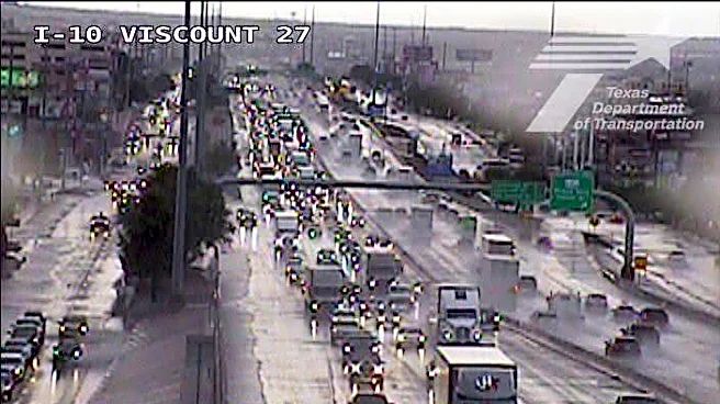
TxDOT cameras show traffic backing up as motorists drive through rain on Interstate 10 near Viscount Boulevard. Water appears to be building up on the side of the highway and Gateway Boulevard.
Cameras located on Lee Trevino and Pellicano drives show vehicles driving through pools of water.
In Northeast El Paso, cameras show a large storm dropping heavy rain near U.S. 54 and McCombs Street.
No major flooding has reported.
See road conditions map
TxDOT provides real-time updates on road conditions, including closures caused by flooding and other hazards. See the latest conditions on the map below:
No major power outages in El Paso
There are small scattered power outages in El Paso, but none affecting more than four homes and businesses as of 4 p.m., El Paso Electric outage map shows.
Rain damages El Pasoans Fighting Hunger canopies
Tuesday’s rain damaged two canopies at El Pasoans Fighting Hunger’s Mercado, forcing the food bank to close the Mercado at 2 p.m. Neighbors still waiting in line were sent home without the food they came for, the organization said in an email.
EPFH now faces the added expense of repairing or replacing that protection while continuing its work to feed families across the Borderland.
Community members and businesses interested in helping with canopy repairs or replacement are encouraged to contact El Pasoans Fighting Hunger. Donations to support the food bank’s work can be madeat FeedElPaso.org.
This article originally appeared on El Paso Times: Updates: El Paso under flood watch as storms bring heavy rain