








El Paso will be under a high wind warningas the first significantcold frontof the season moves into the region.
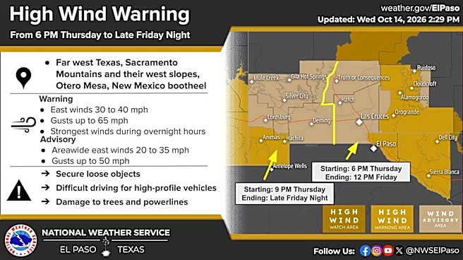
The high wind warning, which covers far West Texas, will be in effect from 6 p.m. on Thursday, Oct. 15 to late Friday, Oct 16. East winds of 30 to 40 mph are expected, with gusts reaching up to 65 mph. The strongest winds are expected overnight.
Residents are urged to secure loose outdoor objects and use caution while driving, particularly in high-profile vehicles. Strong winds could also damage trees and power lines.

Temperatures are also expected to plunge by double digits by Friday, Oct. 16, and could dip into the 40s overnight during early weekend hours, according to the National Weather Service.
By 6 a.m. Friday, Oct. 16, temperatures
are forecast to reach 52 degrees, with even colder conditions expected early Saturday, Oct. 17, when temperatures could drop to 45 degrees by 6 a.m.
While temperatures have typically been in the 80s at thestart of fall, highs through the weekend top out in the low 60s, according to the National Weather Service. Since the cold front will usher in significantly colder air, there's a chance of rain in lowland areas, while higher elevations could see a mix of rain and snow by Friday, Oct. 16.
Scattered rain showers are also in the forecast starting Monday, Oct. 19 and continuing through next Thursday, Oct. 22.

Natassia Paloma may be reached at npaloma@gannett.com, @NatassiaPaloma on X, natassia_paloma on Instagram, and Natassia Paloma on Facebook.
This article originally appeared on El Paso Times: Major cold front to bring damaging winds, chilly temps to El Paso